
Donald W. Clark
September 2001
Prepared at Kodiak, Alaska, for the Native Village of Afognak
INTRODUCTION
The Project
An archaeological excavation by the Native Village of Afognak and Afognak Native Corporation (NVA and ANC) was made at the mouth of the Afognak River at Litnik in 2001 as part of a continuing program for documenting Afognak history. The writer, Lisa Peterson a seasonal employee of the Native Village of Afognak, and two student assistants Analisa Gregoire and Kent Cardwell did the excavation. The NVA Dig Afognak camp at Katanai provided logistical support including camp facilities, meals, lodging and equipment and transportation.
Site Name
In State of Alaska Office of History and Archaeology records the site is designated as part of 49 Afg-215. Excavated sites usually are named. We have selected the name "Tsunami Site" because the site had been inundated by a tidal wave (tsunami) in ancient times. This event probably led to its abandonment, perhaps even the inhabitants perished. We plan to obtain radiocarbon dates that will date the tidal wave.
Summary of Results
A five by seven meter excavation uncovered traces of a subrectangular depressed (semisubterranen) house approximately 7 meters long and 4 meters wide. One end of the house extended beyond the area excavated and was not uncovered. Nearly 300 artifacts were recovered from the house fill and floor. Most of these can be assigned to the house occupation. Implements are mainly ulu knife blades, which would have been used for cutting salmon, abraders and hones used to form and sharpen the ulus, projectile points, and notched pebble net weights. There also were stone lamps and labrets. The complexion of the collection suggests that the main activity was salmon fishing. Artifact styles indicate that the house was occupied early in the late part of the Kachemak Tradition, probably about 2000 years ago.
Previous Work and Selection of Site for 2001 Investigation
Archaeologists had considerable previous knowledge of the Afognak River and Afognak Bay area. Clark had spent the summer of 1951 at Rivermouth Point and in 1971 he and William Workman excavated parts of two Ocean Bay culture sites (4000 to 6500 years old) on the Afognak estuary. At that time an apparent transitional Ocean Bay-Early Kachemak site was located nearby and this was confirmed by test pitting and radiocarbon dating done in the 1990s by the ANC and Canadian Museum of Civilization. Farther out on the bay, portions of a 1000-year-old terminal Kachemak midden at the Aleut Town site were excavated in 1999 and 2000 by the NVA, a Koniag tradition (ancestral Alutiiq) housepit village at Settlement Point was excavated by Patrick Saltonstall in the 1990s, and during the same period Katharine Woodhouse-Beyer uncovered the historic Creole Kataaq or Katenai village, also located at Settlement Point. These projects were part of the Dig Afognak Program. They included also minor excavation, by Megan Partlow, at a Koniag midden site located near the entrance to Back Bay across from Rivermouth Point. Survey done by the writer for the ANC in 1997 further identified the distribution or prehistoric remains along the Afognak River estuary.
However, this work left the greater extent of the Kachemak Tradition unexamined except for collections of artifacts washed out onto the shore. Such collections lack controlled contextual information, delicate artifacts often have been destroyed, and structural features, especially houses, are lost. A testpit dug during the 1997 survey located a probable house structure buried in the soils atop a slight rise located immediately upstream from an Ocean Bay-Kachemak transitional site. Early Kachemak and Ocean Bay artifacts also had been found along the shore farther upstream. The Tsunami site thus offered the prospect for focusing work on a discrete structure with an age that likely would be within the early part of the Kachemak tradition (it turned out to be closer to Late Kachemak). Further information on Early Kachemak houses would broaden the scope of information obtained in recent years at the Bliskii and Buskin Lake Outlet sites by Patrick Saltonstall and Amy Steffian. But, like almost all sites along the river it lacked preservation of bone artifacts. The site held the advantages that it could be reached by small boat at nearly all stages of the tide (a 200 yard walk being required at low tide), that most parts were free of spruce forest, and there were adjacent sites that could be investigated if time remained at the end of the season. Finally, it was hypothesized that, due to its location, the site's inhabitants had focused on salmon fishing and that because of icing of the river and bay there would have been no winter occupation. The dig would determine if these constraints affected the artifact inventory.
GEOGRAPHICAL AND HISTORAL DESCRIPTION OF THE AREA
We refer to an Afognak River estuary. This is actually the tidal lower 1¾ miles of the river, otherwise not particularly estuarine in its characteristics. The extreme tidal range at the bay is 13 feet and it probably is the same at the river. The reach from just above the site out to the nominal minus tide river mouth at Winter Island has a fine sediment or muck bottom. It would be disastrous to attempt to wade across there. A gravel bar appears in the river just above the site at low tide and it probably is safe to cross there, though this was not attempted in 2001 (The writer did wade through that crossing in 1951, before subsidence and tidal waves in 1964 created a mucky bottom.) From there to a point just above the abutments of the bridge that was washed away in 1964 the channel tends to be deep, even at low tide. Sometimes large numbers of salmon congregate there. Farther up, the river widens. Gravel bars are exposed at low tide and a "lagoon" forms at high tide. Water volume fluctuates greatly according to the presence of spring meltwater runoff and wetness of the season. In some years, 2001 for instance, it drops to a mere trickle that salmon find difficult to ascend.
Three species of salmon, plus steelhead, enter the river: red (sockeye), silver (coho) pink (humpback) and chum (dog). The red, silver and steelhead and even some pink salmon continue to the lake to spawn. The runs are principally during the
Figure 1. Map of Afognak Bay showing the location of the Tsunami site (Afg-215).
summer months, but formerly the Afognak River was known for its early salmon arriving in April. Thus, salmon of one species or another were available at Litnik for half of the year. In the past the salmon were a major focus for subsistence, though except for the red salmon their numbers are subject to radical fluctuations. At Litnik, an Alutiiq fishing camp of 40 barabaras was observed at the end of the nineteenth century. But the river is only a second order of magnitude spawning stream compared with the Karluk River and it has seen a disastrous drop in some recent years. By September 4, 2001 the red run escapement had attained a figure of only 24,271. In a good year the escapement of red salmon may exceed 100,000 fish. Pink salmon is highly cyclic and erratic, ranging from about 10,000 to nearly 100,000 fish while only traces of chum and a few thousand up to 11,000 coho salmon appear at the river according to Alaska Department of Fish and Game weir counts. These figures do not include chum and pinks that spawn below the weir or the commercial catch or escapement any year after September 4.
The site is surrounded by dense spruce forest, but there are clearings along the lower reaches of the river. The forest has excluded other plants such as poplar trees and alders (outside clearings). However, there were no spruce trees on Afognak when the site was occupied. Spruce is thought to have reached the island no more than 800 years ago, and Afognak Bay even later, but there has been not detailed study of this nor is there any report of the local vegetation just prior to arrival of the forest. A study by Heusser identifying plant pollen in bogs is too approximate in its dating to be of use to us (Heusser 1960). Nelson did a study near Karluk and based on the pollen profile as a proxy indictor of climate he found that essentially today's modern conditions have prevailed for the last 4000 years (Nelson 1988). The main source for timber would have been driftwood. In addition to the arrival of the forest, major environmental change affected Afognak Bay in the past, but most of this happened before the site was occupied. Some details are given in the author's paper "Afognak Before Russians: Precontact History of Afognak Village and Vicinity", slightly revised 2001, prepared for the NVA.
Earthquakes and tidal waves did occur, and a tidal wave (tsunami) sand deposit was found at the top level of the house occupation at Afg-215. Gary Carver's examination of boggy deposits adjacent to the site revealed that there had been at least 5 and as many as 9 tidal waves both before and after the site had been occupied. Most undoubtedly were accompanied by earthquakes. There evidently have been changes in the level of the land, especially as indicated by studies by Carver, Crowell, Mann, and Saltonstall, by the case in 1964 when the land dropped approximately six feet, and the suggestive fact that the spatial arrangement of sites up the Afognak estuary starts with the oldest sites at its lower end and progresses upstream to historic sites located near the Fisheries weir, just below the falls. Published references to these observations are given in the Afognak prehistory manuscript cited above. There also had been several volcanic ash falls, largely before the site was occupied.
A period of climatic cooling, called the Neoglacial, began about 3500 years ago. Cool conditions of this period probably still held when the site was settled more than a millennium later. At that time the existing limited suite of land and sea mammals already was present. Bones of most species have been recovered from Early Kachemak and Ocean Bay age sites. Thick winter icing of the river would have isolated the site from the open bay. In most years a mile trek would have taken a person to the open coast, to collect shellfish or paddle farther out in kayaks on a sea mammal hunt or to fish in the bay waters. But it might have been much more convenient to move to an outer bay location because in very harsh years Afognak Bay freezes almost as far out as Lipsett Point (Dennis Knagin oral communication to Clark August 2001.
The site has escaped historic impacts. During the Russian period there had been a camp adjacent to the fishing hole up the river, and towards the end of the nineteenth century when two canneries had been built inside Rivermouth Point there appears to have been a fishing station adjacent to the same fish hole, on the right bank. The historic Litnik summer village was located in this area and upstream at the head of the lagoon. A fish trap or "zapor" and dwellings were built just above the limit of tidewater at the site of the Department of Fish and Game weir. The terminus of the early twentieth century tramway that ran up to the salmon hatchery on Afognak Lake was at the riverbank across from the site. Later, the tramway was replaced by a graveled road from Rivermouth Point, which passed about 100 yards from the site.
THE EXCAVATION
Operations in 2001. During the 53-day period of July 6 to August 18, 22 days of excavation were done. In comparison, 28 days were available for excavation during each of the two previous seasons. The crew was shut out from the site for 2½ days because of rain, but that is a modest price to pay for working in the open. Much of that time was utilized to clean and catalog the collection. Time also was lost due to boat motor failures. In addition to the regular excavation team of Clark, Gregoire, Peterson and Cardwell, excavation was assisted by visiting geological specialist Gary Carver, some of the Katenai staff, and participants in various Dig Afognak programs such as Shareholder's Week, the Teachers Academy and the Science Camp. For several days Science Camp participants Justin and Tristan Kewan, Arthur May and Brian Knagin lugged buckets of spoil up to the backdirt pile. At the end, project manager Olga Pestrikoff mustered the whole camp and visiting family members to refill the hole created during the preceding two months. Excavation steps are outlined below (Defining…Structure). Except for removing the turf and underlying volcanic ash, which was done by shovel, all excavation was done with small trowels. A small portion of the material removed was screened. We had planned to check on the efficacy of troweling, for missed artifacts, by screening during the backfilling stage, but the soil from the excavation had become so compacted that it could not be passed through a half-inch mesh. Elevations relative to a temporary datum were recorded for the 2001 ground surface, the pre-Katmai surface, the surfaces above and below a tsunami sand fill, yellow clay floor, stone slabs and the base of subfloor clay lined pits, though these are not given in this report. Artifacts were recorded by two dimensional coordinants within each section and by various indicators of depth including "Level 1" which was the top 10 cm of soil below the 1912 ash deposit, occurrence above a tsunami sand deposit, occurrence below that deposit in the fill above a yellow clay, and occurrence on and below a yellow clay floor. Many items were
Figure 2. The Tsunami site from the shore of the Afognak River.

Figure 3. Cleaning turf and volcanic ash from the site (Kent Cardwell, Analisa Gregoire
and Lisa Peterson).
Figure 4. Layout of the excavation grid at the Tsunami site.
found outside the limits of those deposits and for them depth was recorded. Depth readings often were taken to supplement layer provenience. However, chert flakes and slate scrap and odd stones were collected in various bag lots though upon later examination it was found that such lots sometimes contained "worthy" specimens.
THE STRUCTURE
Defining the House Structure. When the site was gridded into one-meter squares and the vegetation was cut down on July 7 no house pit was apparent. This would have been very disconcerting had we not known from a test pit dug in 1997 that structure traces lay below. Nor was any housepit evident after the sod, a thick 1964 tidal wave deposit and the 1912 volcanic ash layer were removed. Excavation next tackled the dark humic soil that lay under the ash. It was determined that a thick gray sand exposed in the wall of the 1997 test, uncovered concurrently, was a tsunami (tidal wave) deposit, confirmed by Gary Carver who was present at the opening of the excavation. Excavation then focused on exposing the top of the tsunami deposit by removing the relatively shallow overlying soil. But the tsunami sands hardly could be traced to the limit of the area gridded for excavation. After it was exposed, the top of the tsunami sand formed a modest bowl-shaped depression (which on two sides extended beyond the excavation). Next, the fill of tsunami sand was dug out. That left a more sharply defined pit shaped somewhat like a lumpy circle. In places the pit had sharply defined steep walls, in other places discovering the walls required considerable trial excavation of deposits that were not clearly tsunami sand. That having been accomplished, it appeared that we had a structure similar to the oval Kachemak houses recently discovered near the town of Kodiak by Patrick Saltonstall and Amy Steffian.
We next began to trowel out the fill below the tsunami sand, expecting to encounter the house floor. Early in that process we did find a yellow-orange clay layer-the apparent floor. Our stratigraphically controlled mode of excavation focused on exposing this floor. That was a slow procedure as the orange floor dipped and rose, was penetrated by many clay-lined pits, and there were many stone slabs on and just above it.. Caution was required not to trowel too deep and remove the clay deposit. Moreover, traces of an orange layer occurring at a higher elevation at the periphery of the depression that had held the tsunami sand created considerable confusion. On the advice of Patrick Saltonstall, we decided that the upper orange had no relationship to the floor but was from volcanic ash soil brought into the site on the bottom of sods that had been stacked around the house to bank or build up the walls. The orange floor layer was traced to the limit of the depression that had held the tsunami sand. Then, gradually and hesitatingly, we pushed outward, following the clay under brown soil fill. Its limit became very clear at one side of the house when we reached an original house pit cut into glacial till. There was a space between the till and orange floor, probably occupied by the wall. Elsewhere, the till was deeply buried and the cut for the house pit only penetrated overlying brown and orange-brown soil. It was more difficult to follow the edge of the house in that soil. In places it also was necessary to excavate additional one-meter sections to reach the edge of the floor (which never was reached at the west end of the house).
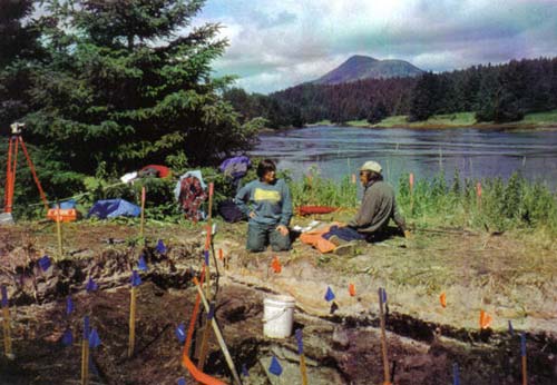
Figure 5. Program manager Olga Pestrikoff and geologist Gary Carver at the site (view
looking up the Afognak River.
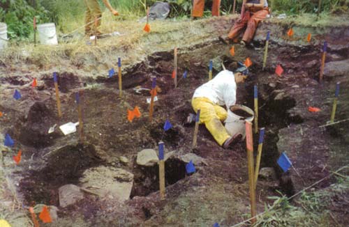
Figure 6. Working out the limit of the tsunami deposit fill (dark edge) and commencing
excavation of stone slabs in the house structure.
This done, the resultant floor was essentially a rectangular area with irregularities. That returned assessment of the structure to the original model of a rectangular single room Kachemak house. Excavation of the orange floor was undertaken next. This revealed, in many places more than a single floor layer. And by tracing a faint dark-stained streak it was found that the floor extended between 20 and 140 cm farther east and at least 2 meters farther west than the orange floor. Floor traces also ran beyond the excavation at its northeast corner. Areas respectively within and beyond the clay floor may have been used in different ways.
The final step was to remove deposits under the orange down to glacial till. In some places excavation of the clay already had reached till. Elsewhere there was a layer of dark soil, a hearth deposit, and a lower orange clay floor and also a filled in clay-lined pit (Fig. 14). Additional sections were excavated at the west end in search of the edge of the house floor and the entry. There the floor was not as deep as the glacial till and had to be traced as slight changes in the color of fine soil.
Post Holes. Archaeologists attach special importance to post holes for the information they shed on house form. Specific house types require concomitant supports. However remodeling or redesign, improvised repairs to ageing homes, and use of posts set on the surface that do not leave recognized traces as well as thoroughly nonstandard design complicate interpretation of the evidence A substantial number of post holes and suspected post holes, i.e., small, deep soft areas with different fill, were found in the Tsunami house. The first substantial hole appeared when the gray tsunami sand was removed. It was surrounded by retaining stones or chock blocks to hold the post in place in the oversize hole it occupied. Subsequently six additional holes with stone settings were uncovered. By the time the clay floor was exposed seven more post holes had become visible and a total of 15 had been found after stripping the floor down to the till. Here are details of six post holes clustered in the northeast quadrant of the house.
Hole 16 cm in wide between rock chocks, 36 cm deep.
Hole 27 cm wide between stone post packs, 30 cm deep.
Hole 18 cm in diameter (actual size of the post), 30 cm deep.
Tapered hole 15 cm in diameter (actual size of the post).
Hole 22 cm wide between stone props at the top, 24 cm deep.
Pit for a very large post 40 cm in dia. The post would have been much smaller.
The large number of post holes is supplemented by three piles of boulders that might have held up low beams, and by a rotted beam or board that may have capped two posts. Nevertheless, it is difficult to see more than tentative structural patterns. In a 4-center-post mode of construction there would be four posts each a few feet apart near the center of the house and a post near each corner. They supported, respectively, upper and lower roof/wall beams. Wall boards were leaned against the lower beam. In a variant of this mode, the center posts were moved out to the end walls where they supported twin ridge poles. That type of framing was used in small historic hunting barabaras. Additional posts could be installed to help support the ridge poles. Cribbed construction, in which several tiers of beams were laid onto or across a grid progressively closer to the center of the structure, forming a domed roof, required heavy end posts. Sometimes additional higher posts were used inside to support subsequent tiers of beams. The lowest beams should be outermost. The height factor enters into consideration of the low boulder piles as possible supports for low outer beams. Although the pattern of the Tsunami site post holes is not clear, and there are options for connecting various posts and boulder piles with bridging beams (Figure 8), it fits best the cribbed roof model. Definitely, construction was not of the 4-center-post type.
Subfloor Pits. Numerous pits were dug into the floor, down into the underlying glacial till (Figure 8). In most cases the pits originated from the level of the clay floor. Only one pit was a void and even it was partially filled with soft sediment that had been washed in. The remainder were loosely filled with the site matrix that occurred above the yellow-orange clay floor. The pits were lined with clayey volcanic ash that occurred in shades of tan and yellow-brown. None were lined with blue-gray glacial till clay which was commonly used at the Koniag Settlement Point site. A preference for volcanic ash clay over glacial till clay appears to be a feature of the Kachemak tradition as that is the material used at the Early Kachemak Old Kava site (Clark 1996). One of the last excavation tasks was to finish cleaning out the pits and remove the clay lining. A small lamp and ground slate point were found embedded in the lining of one pit. Often the clay of the lower walls was found to be different from that of the upper walls. The pits take up a very substantial part of the house floor, and this would have made it difficult to get around inside, except at the west end of the house which was free of pits. Only one was covered by a stone slab but possibly others were covered by slabs no longer in place or by wooden slabs. Too, some might have been decommissioned and filled in. Two filled-in pits were recognized in cross-section when deposits below the clay floor were trowelled out (Fig, 14; not shown in the floor pit drawing)
None was filled with rocks or gravel which should have been the case if they had been used for cooking (food placed over heated rocks, covered, steamed if desired). These are not like the large deep clay-lined storage pits found at the Koniag Settlement Point site by Saltonstall (1997) as they are considerably smaller and shallower. Instead, they are like those found at the Uyak site excavated by Hrdlicka in the 1930s (Heizer 1956:30) and the Late Kachemak Three Saints site (author's notes). Those at Uyak Bay ranged up to 72 cm in diameter and were 20 to 30 cm deep. One of the better defined pits at Afg-215 was 46 cm in diameter inside and 60 cm at the top after the clay lining was removed, and was 43 cm deep. Only one pit, located near the center of the house, was obviously larger thanthat and none was deeper.
Stone Slabs and Boulders. Stone slabs and boulders were numerous in parts of the house. Blocky boulders were localized mainly at and near three corners. They are shown in Figure 8 along with post holes and Figures 15-16. Four were positioned at the southeast corner. An alignment of stacked boulders was uncovered near the northeast quadrant of the house but one meter or more along the wall from the corner. The third group of large stones was located near the northwest corner, one meter or more inward along the wall from the actual corner. Several stacked boulders and stone slabs extended outward from the wall for somewhat more than a meter, forming, in a sense an ell. This feature is complicated by the presence of old excavations into the floor and wall that may be part of a house entry. Details were incompletely recovered as there was no time to excavate adjacent sections with the remainder of this feature. In each of the three cases the top of the boulders was only a few centimeters below the base of the Katmai ash. When the house was last occupied they probably were at the surface and they may have risen slightly above the surface when the house was built. Thus, the boulders might have supported low-level beams, as could have been used in cribbed-style construction.
Three blocks located near the center of the structure have no apparent reason for being there except all are located near the top of a large subfloor pit, and two are at the edges of a hearth area. Finally, two boulders that protruded above the yellow floor clay were firmly imbedded in the underlying glacial till and may be residual features of the terrain, left in place when the house pit was excavated.
Smaller blocks of stone were scattered about the excavations without forming any apparent essential part of defined features. Small blocks also were clustered in the top level outside (south) of the house where they may have been left from a sweat bath. Finally, there was a cluster of angular rocks below the orange floor not accompanied by charcoal and not obviously a cooking feature. At the side of this cluster they formed a border two stones high.
Stone slabs were located mainly in and just above the yellow floor layer (excepting the stacked slabs near the northwest end). One of them, the second largest in the excavation, covered a deep clay-lined pit. Other slabs appeared to form a linear feature running obliquely across half the structure, as shown in Figure 7. Some were layered, one atop another. However, removal of the slabs failed to reveal any apparent reason for their presence, except at the inner end. There was nothing underneath except dark brown soil with the exception of two slabs at the end of this alignment. Those two were part of the cover of a short shallow crypt. This crypt was only about five inches deep and was floored by additional slabs, shown in Figure 13. As for the other slabs, possibly they had been lifted off some of the subfloor pits, laid to one side in a line, and had not been replaced.
The Entry. A tunnel-like entrance passage, which would have survived in the form of an infilled ditch, was expected on the basis of excavations at Kachemak houses elsewhere (Steffian 1992). No entrance was found, but the western end of the excavation failed to reach the edge of the house floor. In the very northwest one-meter section, the floor plunged downward about 9 inches and the dark fill there extended beyond the section into a cut that had been made into the north wall of the house. This feature is the best candidate for elements of an entry, though its position near a corner of the structure is peculiar. Excavation did not progress far enough to trace this feature.
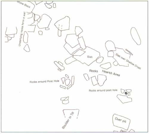
Figure 7. Stone slabs and boulders in the Tsunami house.
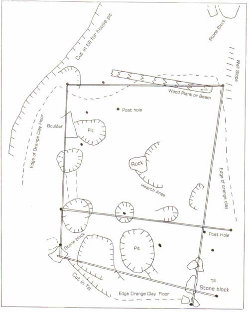
Figure 8. Subfloor pits and post holes in the Tsunami house with one possible
arrangement of beams.
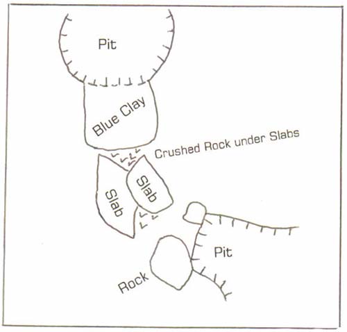
Figure 9. A small pit, clay, slab and crushed rock feature.
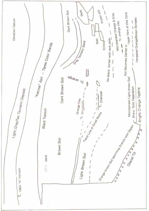
Figure 10. Stratigraphy at the west side of the excavtion.
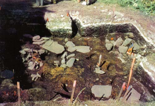
Figure 11. Excavation completed down to clay floor and stone slabs (from south edge).
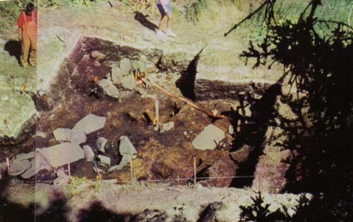
Figure 12. The excavation completed, from the west side.
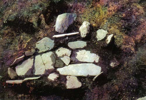
Figure 13. Shallow slate slab feature on the floor, bottom slabs. Side slabs are about 7
inches high; cover slabs (in earlier drawing) have been removed.
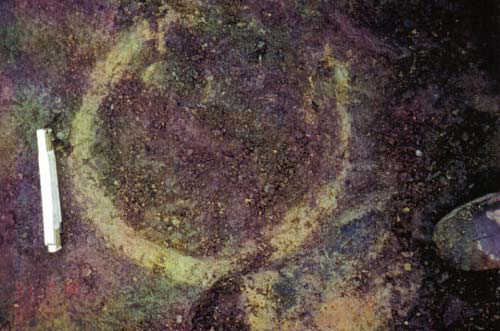
Figure 14. Section of old infilled clay-lined pit.
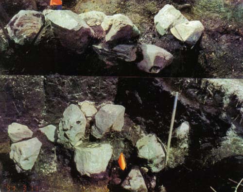
Figure 15. Boulder alignment near east wall (lateral and top views).
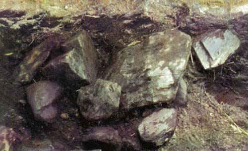
Figure 16. Boulder pile near north wall (note shallow depth below volcanic ash layer).
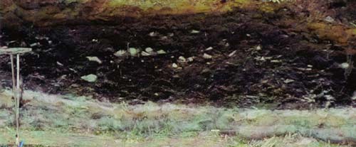
Figure 17. West wall of the excavation. Edge of the house pit slopes up to the left.
ARTIFACTS
In addition to the excavations, the shore in front of the site was inspected for artifacts. The site is underlain by bedrock and consequently it is little eroded. Two notched pebbles were seen but were not collected. An examination by the author in 1971 also yielded sparse results.
After the lamps we describe ulus and other knife blades. Then we turn to artifacts for hunting, weapons and fishing. Description concludes with the personal adornment category and miscellaneous objects.
TABLE 1: LIST OF ARTIFACTS
| Identification | Number |
| Stone lamp | 3 |
| Stone lamp, unfinished | 1 |
| Stone lamp, miniature | 1 |
| Ulu blade, complete | 19 |
| Ulu blade major fragment | 31 |
| Ground slate minor fragment | 79 |
| Tool slate | abundant |
| Flensing knife, fragment | 7 |
| Heavy flaked chert bifaces | 3 + 2 large basalt in 1997 |
| Flaked chert sideblade & small knife | 2 |
| Grooved cobbles | 5 |
| Notched pebble sinkers | 50 |
| Perforated pebble | 1 |
| Projectile tip | |
| Ground slate | 12 |
| Flaked stone | 11 |
| Egg-shaped cobbles | 7 |
| Small spheroidal and ovoid pebbles | 5+ |
| Cobble maul fragment | 1 |
| Hammerstones | 10 approx. |
| Cobble spalls, utilized | 6 |
| Cobble spalls, other | 20 |
| Adze bit | 3 + 1 in 1997 |
| Burnisher | 1 |
| Abraders and hones | |
| Pumice and scoria | 19 |
| Tabular siltstone hone | 8 (+2?) |
| Bar-shaped sandstone | 8 |
| Tabular and irregular sandstone | 11 |
| Other | 3 |
| Ulu-shaped (stone sheet) scrapers | 17 |
| Flaked chert scrapers | 3 |
| Labrets & fragments | 5 |
| Pigment block | 2 |
| Beads | 4 |
| Slate pin bipoints and slender slate rods | 3 |
| Total | 360 |
Lamps
Household paraphernalia is limited in the present case to stone lamps. One lamp actually is a miniature, too small to have been functional, and it does not belong in the implement category.
Another lamp is small, 8.6 cm long and weighs 209 grams, but it is fully formed and it could have been functional, though judging from the absence of char on the wick shelf it may never have been used. It has a prow, somewhat like a bow, that extends back under the lamp for a considerable distance like a keel. Such prows are characteristic of Kachemak tradition lamps, though they are present only in a minority of specimens.
Only the back half of a larger, yet small, very well fashioned, plain, thin lamp was recovered, although all the adjacent sections of the site were excavated.
The lamp of the household, a medium-large 19 cm-long specimen weighing 1485 g, was found upside down, as were the other lamps, in the bottom of a large subfloor pit. It is plain but has a well-formed border and rim and a slight prow. Char at the wick ramp attests to the fact that an oil flame once flickered in this lamp.
Also found among cobbles stuffed into a post hole was an unfinished lamp made on a large thick greywacke cobble.
Ulu Blades
Ulu blades tend to be oval to rectangular in shape, with slightly concave cutting edges. Highly arcuate or semilunar specimens are rare. Complete blades average 9.8 cm long, major fragments 8 cm. Complete blades plus major fragments, numbering 50 are tied with notched pebbles for the distinction of being the most abundant artifact, but the number of minor fragments push the representation of ulu blades well into the maximum category. This attests to the importance of processing salmon. Two blades (one a fragment) are deeply notched at the ends towards the back and three more (fragments) have shallow notches. This style is found in late Kachemak sites elsewhere, especially at Kachemak Bay (Heizer 1956:Pl. 38e, deLaguna 1934:Pl.33). Two blades had a drilled hole to assist hafting.
Slate Blade with Edge at End
A 10-cm-long tabular slate blade has a cutting edge prepared across the 4.4-cm-wide end.
Slate
Fragmentary sheets of slate suitable for fashioning into ulu blades and other ground slate implements were common. In some cases the slate evidently was being flaked to form tools. It grades from tool quality slate to much poorer or grainy material. Often slate slabs were seen to be parting naturally into thin sheets. This mode of occurrence conditions presented a disincentive to collect slate, though a number of specimens were retained. Overall, it appears that slate for manufactures was readily available in the vicinity and that slate tools were being made at the Tsunami site.
Flensing Knives
These are elongate knives that are sharpened on both edges (sides) as well as around the unpointed distal end. This knife format is recognized in one nearly complete specimen while basal fragments with two or three drilled holes and in one case also a butt notch identify this implement type (see Heizer (1956: Pl. 48:f-h). The perforations show the careful Kachemak mode of drilling in which the two halves of the perforation, drilled from opposing sides of the tool meet perfectly with little taper within a slightly biconical hole. It was proposed earlier (Clark1974) that this was accomplishing through drilling to the extent that the hole just began to break out on the opposite side and then the implement was turned over and the hole was "back drilled" from the second side. These knives commonly break across the base through the perforations. That is less likely due to weakening from the perforations than to the fact that this is the point of juncture between blade and haft.
In addition to the nearly complete blade broken through the perforations, and three drilled lower end fragments, there are three sharp rounded ends of blades. One is 9.3 cm long and probably represents half of the complete specimen.
Chert Sideblade Knife
This is a small sharp blade flaked from milky chert or chalcedony. It is 4.7 cm long. Tools of this format are mounted in the side of an elongate handle. They are characteristic of the Bering Sea region and northward 1000 years ago and earlier.
Fishing
Fishing artifacts were limited to weights for nets and lines. The probable line weights are cobbles of varying sizes ranging from 6.1 cm to 11.7 cm length and 176 grams to 846 g in weight. Several groove patterns are present in the five specimens: (a) short grooves over the two ends (2 specimens), (b) a groove around the middle (1 specimen), (c) a groove around the middle and over one half meeting this encircling groove (2 specimens), and (d) an encircling groove placed towards the end but not far enough to produce the plummet shape seen on Early Kachemak weights.
The notched pebbles, which number 50 examples, vary by a fair degree from one another in size with the exception of a clustered group of 12 specimens which are of a uniform size. Specimens in the cluster average 110.7 g in weight and 72.6 mm in overall length. Length falls between the extremes of 66 and 82 mm or 66.6 mm average measured inside the notches. The remaining 38 average only 66.3 cm long between the extremes of 42.5 and 92 mm (58.9 cm ave.inside the notches) and average 60 g. These pebbles bear a battered and sometimes smoothed notch at each end and, in one case, at the two sides. There is little doubt that they were net weights, and that the fish to be caught were salmon. Herring also appear in Afognak Bay in large numbers to spawn, but we have been told that their spawning habitat does not include the Afognak River.
There also is a single pebble with a natural perforation. It may have served in
place of a notched pebble.
Weapons: Projectile Points
Only the stone tips of weapons or hunting implements were recovered due to the decay of wood, bone and antler. They are for spears, darts, and arrows and possibly to tip bone harpoon heads, but it is difficult to determine for which application each of the present specimens was intended. The number of bone and antler spear, fishing prong, bird dart, harpoon and arrow heads once likely to have been present probably exceeded the number of stone tips.
TABLE 2: PROJECTILE POINTS
| Ground Slate | |
| No.* | |
| 3 | Midsection, possibly willow-leaf format, flat lenticular section, 14 mm wide. |
| 25 | Face of elongate point, willow-leaf?, end missing, 58 mm long, 15 wide. L1. |
| 155 | Frag.of point with weak medial ridge, possibly tapered stem, 49 mm. Orange clay |
| 177 | Willow-leaf shape, thin, 14 mm wide, 65 mm long, base thinned, tip damaged. (illus.) 79 cm below turf. |
| 263 | Willow-leaf shape, complete blade, no medial ridge, 99 mm long (illus.). |
| 218 | Tip fragment of point with medial ridge. 91 cm below turf. |
| 338 | Narrow (8mm) with pronounced medial ridge and squared offset stem 39 mm |
| frag., illus. Uncommon format, see Heizer 1956: Pl.46 I. 43 cm below Katmai. | |
| 356 | Incomplete spear point with weak medial ridge, 63 mm tip end frag. (illus.). 58 cm below Katmai. |
| 357 | 55-mm-long midsection of large spear head, weak medial ridge (illus.). |
| 359 | Tip of point with pronounced medial ridge. 36 cm below Katmai. |
| 389 | Tip fragment, 85 cm below Katmai. |
| Flaked Stone | |
| 77 | Red chert, 31 mm long, 11 mm wide, Willow-leaf, very well prep. (illus.). |
| Above orange clay floor. | |
| 29 | Red chert, 31 mm long, 16 mm wide, Ovoid blade (illus.)Level 1. |
| 63 | Red chert, 19 mm long, 11 mm wide , Tear drop-shaped tiny biface, tool |
| tip? Point very thin, not very well made (illus.). Under tsunami sand. | |
| 126 | Basalt (weathered gray) 44 long, 25 mm wide at shoulders. Stemmed point, |
| nearly square stem has prononunced sloping shoulders, not finely prep. (illus.) | |
| At wall?, above orange . | |
| 211 | Basalt (weathered to cream color) 31 long, 9 wide Lanceolate, slight stem, straight narrow base, delicate but not as fine as Denbigh ASTt. House floor 107 cm below top of turf. |
| 227 | Red chert, 46 mm long, 17 mm wide, Large tapered stem with slight offset, slightly asymmetrical, not finely prep (illus.). |
| 244 | Non glossy dark gray chert 39 mm long, 13 mm wide, tapered stem, pronounced sloping shoulders, concave edges, well prep. (illus.). In pit penetrating the floor. |
| 260 | Red chert, 29 mm long, 11 mm wide, Leaf shaped, well prepared (illus.). Fill of subfloor pit. |
| 290 | Basalt (weathered gray), 20 mm wide, Spear tip frag., very well made |
| (illus.). Under slate slab at or below orange clay floor. | |
| 359 | Red chert, 14+ mm wide, 26 long Tapers to slightly rounded base, tip thick (unfinished?), not finely prep. (illus.). 36 cm below Katmai ash. |
| 367 | Red chert, 53 mm long, 17 mm wide Leaf shaped, thick asymmetrical stem,not finely prepared (illus.) 80 cm below Katmai. |
*Prefix with "AM436."
Blunted Stone Sheet Scrapers (Ulu-shaped Scrapers)
Seventeen slate sheets and fragments have chipped or blunted edges.. Some may have been intended for further fashioning, i.e., grinding, into ulu blades. In many cases the stone is grainier than the slate usually used for ulus. Fine chipping and blunting of edges, mainly in cases involving the coarser stone, is interpreted as evidence for use in scraping, as on hides.
Slate Pins
A carefully prepared bipointed pin is 7.4 cm long. The very tip of one end actually has been ground flat. There also is the pointed end fragment of another pin. A nearly identical specimen was found earlier on the eroding river shore across from the site and Heizer (1956) illustrates one from the Uyak site.
Egg-Shaped Cobbles and other Natural Stones
Examples of spherical, oval and elongate rounded pebbles and cobbles were collected but many unmodified pebbles were discarded. There were no clusters of large pebbles and cobbles that could have been used for cooking, especially for stone-boiling. Except for one case the cobbles were not "burned." There was at floor level one cluster of 10 flat pebbles. They are only moderately variable in size and shape, most being between 5 and 6 cm long within a 5 to 7 cm range. They weigh 35 g each, on the average. The reason why these pebbles were collected is not known; they are only half the weight of the average notched sinker.
Representative spheroids are 3.5 to 4.5 cm in diameter, ovoid or egg-shaped pebbles are 5.7 cm long. A small greywacke cobble of roughly cylindrical format is 16.5 cm long and weighs 249 g. Excavators observed the frequent occurrence of quartz pebbles and suggested that they had been accumulated in the site. They in a size range of up to 12 cm (in that case elongate). Three are fractured, the rest unmodified. No quartz hammerstones were recognized.
Larger ovoid or egg-shaped cobbles drew especial notice as they would have had to come from high-energy beaches located on the bay some distance from the site. All but one of the few examples recovered were collected (this excludes irregular smooth cobbles that were discarded and hammerstones). The 7 specimens range from 6.2 cm long weighing 118 g to 13.5 cm long weighing 1593 g. The last had been slightly used as a hammer.
Burned Cobble
"Burned" (heat altered) slate which probably is derived from hearths and sweat baths, a form of banya, was common, though it did not occur in massive deposits in the manner that it does after 1000 A.D. at Koniag tradition sites. A single reddened burned cobble that weighs 729 g was collected and it is unlikely that any clusters of such stones were overlooked. Clusters, or even dispersed multiples, would have been sets of rocks used for the cooking process known as stone boiling in which rocks are heated and then immersed in the water or soup to be brought to a boil. This procedure was widely and effectively used in parts of North America, though it was not described by historical ethnographers for the Alutiiq.
Hammerstones
Cobbles were used as hammers and maul heads. Large cobbles that sometimes bear a pair of pits on the sides, probably to assist hafting, are common on the beaches at many eroded sites, especially Kachemak tradition sites. They may have been used to drive stakes for fish weirs. However, only the broken half of a single specimen was excavated (not collected) and none was found on the shore adjacent to the site. If the inhabitants of the Tsunami site had a fish weir it must have been located away from the site. These cobble mauls proably would have been cached close to their place of use.
Hammerstones bear surface areas crushed or pulverized from impact. Such use traces vary from a trace to extensive modification. All of the obvious hammerstones, which were not numerous, were collected. They would have been used for the initial stage of flaking chert for implement blanks, to peck notches and grooves in pebble weights and grooved stones, to strike cobbles to detach large clam-shell-shaped spalls (boulder flakes), to hollow and shape stone lamps, and to shape blanks for adze bits (uncommon) and slate blades. Some probably were hafted and used as club heads and to drive bone and wooden wedges. Others were held by hand.
Their form ranges from battered pebbles of irregular to elongate to rounded shape, to heavy elongate cobbles. 20 to 27 cm long and weighing up to 1690 g, with battering at ends or on the sides near the end.
Ocher Grinders
Pale terracotta toned pigment occurred commonly in the site deposit but no bright red ocher was recovered. Three small blocks of this stone were recovered as well as specks and smudges. It appears to be soft enough not to require crushers and grinders for its reduction to a powder. Nevertheless, a rounded 11.5 cm-long cobble with impact roughening typical of hammerstones at one end, bore a thick red-brown crust of staining at the other end. Most of the pigment washed away upon light cleaning.
A portion of a large cobble of dark intrusive igneous rock is crushed and reduced at one end in the manner of a well used hammerstone, while one face is worn flat and very smooth (facetted) in the manner seen elsewhere on ocher grinders. This stone is not local but may be found on the opposite side of Kodiak Island were it is derived from glacial deposits carried over from the mainland.
Cobble Spalls
Cobble spalls or boulder flakes were a universal tool. They are large clam-shell-shaped flakes struck from rounded cobbles. The result is a tool with thin, relative sharp edge and thick easily held back. Striking the cobble, which required considerable force, did not always produce a well-formed spall with usable edge, so there is much cobble industry waste in site deposits. The popularity of this tool varied through time and from place to place. Locations without a local source of cobbles usually produced equivalent tools in an alternative mode from thin slabs of stone. Sometimes, especially in the Early Kachemak tradition, the spalls were shaped further for use as scrapers and even as adze bits. Boulder flakes served for a variety of tasks: as hide scrapers, fish cleaners, to saw slate and other materials, to scrape wood and for narrow-edged chipping hammers. Those used as saws (mainly a late Ocean Bay application) and intensively as scrapers wear to smoothed edges.
An effort was made to collect the cobble spalls and 25 examples were acquired. This is a modest number considering their abundance at some Kachemak sites. Five small ones may have broken off large hammerstones or mauls and not all such small pieces were collected. In contrast with naturally split stones, usually a spall bears an impact scar or crushing at the thick back from the blow that detached it. They tend to be longest in the width dimension, from side to side. Typical specimens are 9 to 13 cm long, though some are larger or smaller. The assemblage was examined for shaping or modification of edges and also for smoothing that could be a result of use. Five specimens are smooth at the edge, probably from use as scrapers or saws (27A, 148, 151, 245, 267A). One more specimen is battered blunt at the edge and probably was used in a somewhat different manner for scraping, or had seen too little use to wear the edge. It is uncertain that the remaining 14 spalls had been utilized.
Chisel
A small 4.2 cm-long ground slate bar is battered at one end. The other thinned, sharp end has been impacted or damaged, probably from use. We interpret it as a small chisel.
Adze Blades
Adze blades are represented by a small, complete, sharply beveled specimen (illus.) and three others. The bevel forms a very steep angle, about 50-60 degrees, with one face of the blade. This specimen is only 1.9 cm wide at the cutting edge. A second well prepared tabular adze blade also has a single bevel angled at about 40 degrees side. It is incomplete but was at least 2.1 cm wide at the bit. In the 1997 test there was a finely prepared tabular adze blade that is broken at the bit. The high degree of preparation shown by these pieces is unusual, even for the Kachemak tradition. Finally, there also is a butt-end fragment of a large roughly prepared adze.
Burnishing Stone
A 6-cm-long tabular pebble is worn flat on one edge. Two facets that intersect at a low angle form the flat edge. It fits the conventional description of burnishing stones which are thought to have been used to smooth and polish wooden implements.
Whetstones and Abraders
Whetstones, hones and abraders occurred in a variety of shapes and types. They probably were used for shaping, smoothing and sharpening slate to form ulu blades and other slate tools and to finish wood and bone manufactures. The following description is tailored to the present collection but it probably also applies generally to Kodiak.
Pumice Lumps and Scoria. Small unshaped pumice lumps, 2-3 cm wide, more or less, have surfaces worn flat from use. Frequently Kachemak tradition pumice was red-brown colored. People selected this material from a natural distribution floated to local shores where the reddish color occurs infrequently. There are 12 specimens in this category. White or off-white pumice, which is the material that most frequently can be collected from the high tide line today is represented by 5 specimens. Different from any of these is an abrader of rare black pumice (illustrated) that is flattened on one face and at the ends and rounded over the other surfaces It is shaped like half a short split cylinder. This form is unusual. Scoria is coarser and heavier than pumice, with which it intergrades, and frequently is black colored. There is a single tablet of black scoria, worn flat on two faces (illustrated)
Sandstone Whetstones. Other whetstones and hones are made of sandstones and siltstone of varying degrees of fineness. The distinction between whetstones and hones thus is somewhat arbitrary. Sandstone was shaped into small bars. There are 8 specimens of this type. A typical example (illustrated) is 6 cm long. Split flat pebbles and sections from flat sandstone pebbles and cobbles, often recovered as fragments, are worn flat on one or both faces. These are larger than the rectangular bars and are up to 11 cm long. Eleven whetstones can be placed in this group. An additional abrader is elongate and triangular in cross-section, worn on the three sides. An irregular small lump and a small bar with oval section and a ridged edge, a shape that possibly arose from use, completes the suite of whetstones.
Hones. The 8 hones were made from sheets or fragments of fine-grained sedimentary stone. They are worn flat on one of both faces and sometimes have been blunted on the edges. Form often is irregular, but most specimens recovered are fragments. Additionally, 2 pieces of slate have perfectly flat finely smoothed surfaces that do not even exhibit wear or use striations. They may be fragments from a large honing block, a format known elsewhere on Kodiak.
Chert Scrapers
Two flaked chert scrapers each of a different format were recovered. One is a small 36-mm-long slug-shaped uniface completely flaked over the dorsal surface. This style of tool and the orange-red chert from which it is made are foreign to Kodiak but would not be unusual at Unalaska in the Aleutian Islands. The other item is a red chert flake retouched or shaped around the edges, about the size of a man's thumb, and appropriately can be termed a "thumbnail scraper."
Flaked Chert Industry
Projectile points and scrapers and a knife blade flaked from the flinty rock "chert" are described earlier. More than 500 flakes and shattered pieces of red chert, shichis a local materisl, and 3 flakes of milky colored chert were recovered. This attests to the apparent importance of manufacturing flaked implements from that material, but only 13 chert implements were found, plus 2 basalt artifacts recovered in the 1997 test, in addition to the 10 projectile points. Possibly the fractured nature of the chert from Afognak Island and Raspberry Straight required that quite a lot of raw material be processed to obtain blanks for finished implements.
There are portions of 5 large, rough and evidently unfinished bifaces (2 illus.). A biface in this instance is a stout knife blade, flaked on both faces and sharpened on the principal edges, with a rounded broad butt end and a semi-pointed tip. There also is an end of a small roughly-formed biface. Another specimen, again roughly formed, has straight sides but lacks both ends and appears to be the midsection of a lance blade or spearhead. It is made of an uncommon olive-brown chert. In addition, 2 heavy basalt pieces were found in the 1997 test. One is complete and is smoothed at the edge on one end and side, as if it had been used for scraping. The other one is a very broad midsetion fragment, much larger than the unfinished chert specimens.
A whole roughly formed ovoid biface is only 4.2 cm long. It may have been intended for further flaking into a thinner implement-a point or a knife blade-but the material likely proved to be so badly flawed and difficult to flake that it was discarded.
A thinner better fashioned tiny biface blade is obliquely pointed at one end and may have been similar or rounded at the other end, part of which is missing. It is only 3.3 cm long and 2.1 cm wide (not illus. by oversight).
The thick fragmentary end of a heavily utilized scraper, probably an end-scraper was found. Two more delicate scrapers, the thumbnail and slug-shaped ones described above, complete the assemblage of flaked stone tools.
Personal Ornaments
Labrets. One small fine labret of jet, a form of coal, has a flaring encircling flange as also does the half of a larger broken specimen (both illus.). Another jet labret fragment had an encircling groove, thus obviously was a different style, but it is broken on both sides so the form of the complete piece is problematic. One labret with flange and large stud was made of stone that had decayed from age of or compact bone. Additionally, there are two minor fragments of jet labrets.
Beads. Four cylindrical beads are made of a soft salmon-colored or terracotta red stone that is thought to have been obtained from Kachemak Bay. They have essentially untapered central perforations, showing that the inhabitants of the site had a well- developed drilling technique. The smallest bead is 7.5 mm long and 6.5 mm in diameter. The larest one is 14.7 mm long and 9.8 mm in diameter. It has an encircling groove that possibly was intended to part the piece into two beads. A tiny rectangular tablet and a partially shaped cylinder of the same material also was recovered.
COMPARISONS AND INTERPRETATIONS
Occupations of the Site and their Duration
It is not uncommon for artifacts to be dispersed throughout the soil of a site, in small numbers up to the base of the 1912 volcanic ash deposit even though occupation may have ended one or two thousand years earlier. That was the case at Afg-215, but here there is a distinctive layer of tidal wave-deposited sand, the tsunami sand, separating the house features and fill from the topsoil deposits containing evidence of occupation postdating the house. We interpret all material found below the tsunami sand as belonging to the house occupation. When the pit was dug for the house and walls erected therein there was some space between the wall and the pit, outside the house, this was filled in, probably soon after construction. The few artifacts from that fill, however do not suggest that they were derived from an older occupation of the site preceding the house by any notable degree.
An assemblage of artifacts was obtained from soil above the tsunami sand, or from equally shallow soil in sections where the tsunami deposit was not present. They were accompanied by numerous pieces of stone of cobble size and slightly larger, possibly from a sweat bath, and one stone slab but no structure feature was recognized. Collections from this occupation included the following items:
Relatively numerous red chert flakes
Half a well made lamp
Pumice abraders
Black scoria abrader
Stone hone
Notched pebble sinkers (uncommon considering their usual abundance)
A cobble spall
Willowleaf-shaped slate point
Small ovoid red chert blade
Ulu blade drilled for hafting
Ulu blade fragments
Chert thumbnail scraper
Red stone beads
Cobbles grooved around the middle and completely over one end to meet
Adze blade fragment
Although this assemblage is weak in flaked projectile points, it is not appreciably different from that of the house occupation. It appears that there was renewed camping on the site soon after the house had been inundated by tidal waves. All the artifacts from the site can be grouped into a single major period of occupation.
Comparisons with Interpretations
Kachemak Tradition. It is proposed that the site belongs to the beginning of the Late phase of the Kachemak tradition. To enrich the findings from the Tusanami site, which lacks bone preservation, we describe this phase of Kodiak's archaeological sequence as has been determined from the investigation of numerous archaeological middens. Three sequential archaeological traditions are recognized on Kodiak. The first one Ocean Bay, has a distinctive flaked stone and sawn and scraped slate technology. About 1900 or 2000 BC (calibrated age) the Kachemak tradition developed, probably as an outgrowth of Ocean Bay. This is a basic old North Pacific culture with strong ties to Paleo-Eskimo cultures of the Bering Sea region and with the Aleutian Islands. By about 1200 AD Kachemak had become the Koniag tradition which basically is the ancestral culture of the Alutiiq people encountered by the Russians in 1763.
Early Kachemak appears to be a Spartan, utilitarian culture, but interpretations of it are biased because artifact recovery is limited largely to stone tools. Some bone was found at Kachemak Bay by deLaguna (1934). The stone tools originally were only a small part of the Kachemak set of utensils. Late Kachemak was more elaborate with much attention given to ritual treatment of the dead, to personal adornment, a profusion of labrets, and stone oil lamps that expressed male and female deities. Kachemak made great use of grooved cobble and notched pebble weights, probably for fishing lines and nets. The broad, single edged ground site semilunar knife or ulu, a hallmark of Eskimos, gradually became common. Double edged blades, sharpened around the rounded end, called flensing knives, also were used. Toggling harpoons first appear on Kodiak.
For the period of about 300 BC onward, elements of art, ceremony and decoration become commonplace in collections. There is better preservation of bone (and antler) artifacts. Recovered tools now include delicate eyed needles, wedges, harpoon heads and harpoon sockets (at end of shaft) in various styles, arrow heads, fish and bird spear prongs, fish hook shank and barbs, and fish effigy lures. Adze blades and sockets (to attach to a handle) are known but the blades are small, though well fashioned, and are not numerous compared with their abundance in Koniag times, possibly indicating less heavy wood working. Stone technology relied overwhelmingly on ground slate, for ulus and other knives and weapon tips, though a few items were flaked from chert, more so early than later and on Afognak Island than to the southwest. Ornaments, used mostly as jewelry, included stylized and naturalistic human and animal figurines, the labrets, and various beads made from jet (coal), amber, shell, ivory and a red stone from Kachemak Bay. Exotic materials were imported. There also were nose rings and pins and other elaborately carved ornamented pins, possibly to secure clothing. Stone lamps became large, up to 90 pounds, and sometimes portrayed bears, whales, humans and female breasts with evident religious intent.
Kachemak houses are best known form Steffian's excavations (1992) of a Late Kachemak site at Uyak Bay. These had below-floor-level (cold-trap type) entrance passages on one side, half to fully the length of the rest of the house. The single rooms tend to be 13 feet square with a central stone slab hearth, which contrasts with later multi-room Koniag houses. Many houses had small to medium-size clay-lined pits built into the floor, and also clay aprons around the hearth.
Comparisons with other Sites of the Kachemak Tradition. There are a number of Kachemak.site assemblages from Kodiak with which the Afg-215 collection can be compared,. The objective of comparisons is to determine if Afg-215 is typical or whether is variant or regionally different, and to see what technological limitations are associated with the situation of the site as a salmon fishing station not likely to have been occupied during the winter and early spring months. Changes in the technological inventory due to age differences may also occur.
One difference for all these sites, including both Early and Late Kachemak components, in relation to the Tsunami site is the lack of barbed slate spear heads at the latter. The few ground slate points that are complete enough to be classified are of an unbarbed format. There were instead a number of flaked chert and basalt points. The incidence of flaked points there is out of keeping with their relative scarcity in Late Kachemak, an enigmatic occurrence in one group of Uyak site houses excepted (Steffian 1992) and also exceeds their incidence in Early Kachemak components where there is at least a modest amount of flaked stone. There is tentative evidence from surfce collections at the Afognak River and from an excavation by the State of Alaska Office of History and Archaeology on Shuyak Island, as well as from Cook Inlet, that in the northeasterly part of its distribution the Kachemak tradition had a stronger flaked stone industry than it did on parts of Kodiak Island.
Also missing from the site on Afognak are stemmed (often serrated) double-edged knives (broad flensing knives excepted). Such blades were common at the Early Kachemak Old Kiavak site (Clark 1996) and at Late Kachemak Three Saints (Clark 1970), present also at the Uyak site (Heizer 1956) but, not very common at Crag Point and essentially absent at terminal Kachemak Aleut Town (Clark 2000). Their absence at Afg-215 is not to be laid to the age of the site but appears to be a geographic variant.
Recovery of notched pebbles, 50 specimens, approximately meets expectations, though we would not have been surprised if twice that number were found. Data from several sites indicate that at nearly 10 cm length Early Kachemak notched pebbles usually are considerably larger than Late Kachemak notched pebbles. Those from Late Kachemak Three Saints average 58 mm (and 45 g weight) and those from Crag Point 54 to 62 mm in various lots. The Afg-215 notched pebbles are 66 mm long (60 g weight) for thegeneral lot and 72.6 mm (111 g) for a cache of 12 specimens. In a strict size-age ranking the Afognak specimens would be older, but the greater size there may be local without chronological significance. The case is different for Early Kachemak site Afg-088 where the notched shingles are clearly in a larger size order.
The house appears to have been of an elongate format. We did not recognize any evidence of raised platforms around the sides although artifacts were distributed outside the floor limits; tentative discovery of an entry places this feature at a corner of the house; there were no enclosing stone slabs around the hearth although slabs were common elsewhere in the structure; and at the Uyak site the clay lined pits are grouped closely around the hearth. In all these attributes the Tsunami house differs from Late Kachemak houses reported by Steffian (1992). The only similarity is in their comparable floor area. Inasmuch as only one structure was excavated in 2001, we hesitate to assign much significance to these differences lest the results be atypical or incomplete.
Cobble spalls often are a feature of the early phase of the Kachemak tradition. The moderate recovery of 25 specimens, only 6 of which appear to have been utilized, and the absence of extensive modification or reshaping the spalls, as was found to be the case at Old Kiavak, argues poorly for an Early Kachemak date for the Afognak assemblage.
The situation with adze blades common to Kachemak tradition sites elsewhere on Kodiak-fewness, small zize and well finished faces-holds as well for the Afognak River site.
Notable differences observed at the Tsunami site, compared with the rest of Kodiak archaeology during Kachemak times are a greater reliance on flaked chert implements, a shortage of barbed ground slate points, absence of serrated and lugged-stem double-edged knives, and a differing house form. Whether these differences are peculiar to the 2001 excavation or signal the existence of a local variety of Kachemak culture remains to be assessed in the light of results from research elsewhere on Afognak Island. Reporting of excavations at Malina Creek, done10 years ago, are awaited for this.
Cultural Placement and Dating
In the placement of the Tsunami site assemblage within the major cultural traditions on Kodiak (Ocean Bay, Kachemak and Koniag which is ancestral Alutiiq) it is obvious that it is Kachemak. This assessment is made both on the basis of its lacking certain diagnostic elements of the Ocean Bay and Koniag traditions, and from its own attributes. The latter include labret styles, use of notched pebble net weights, adze blade attributes, and flensing knife blades with multiple drilled holes to assist hafting.
The Kachemak tradition was of very long duration, about 1500 BC (almost 4000 BC in adjusted or calibrated "true age" radiocarbon dates). There is some question of where within this long-lasting tradition the excavated site fits. Most of the implement styles found in 2001 have been recovered also from Late Kachemak sites postdating about 200 BC. However, the amount of chert flaking found at Afg-215 is suggestive of Early Kachemak. Moreover, the site lies immediately adjacent to an Ocean Bay-Early Kachemak transitional camp, Afg-088, and artifacts found a few hundred yards farther up the river, on the same side also are very early judging from finds of a plummet-type grooved stone and an Ocean Bay style adze blade. The question of its age and placement may be decided when charcoal samples collected in 2001 are assayed for age. Tentatively, it is proposed that the site occupation belongs to the early part of the Late Kachemak phase and is about 2000-2300 years old.
CONCLUSIONS: Afg-215 AS A FISHING STATION
Judging from its location on a prominent salmon stream in a place that may have been unsuitable for winter occupation, it is highly likely that the Tsunami site was a salmon fishing and processing locality. From that we have the following expectations:
Sinkers for nets and/or mauls for driving trap and weir stakes
Numerous ulu blades for cutting fish
Numerous whetstones and hones for manufacturing and sharpening ulus
A normal complement of weapons to ward off bears and human intruders.
A normal complement of household items and other tools
Some artifacts for fishing and hunting on the sea as it is not far from the site
to the main part of Afognak Bay.
Data for selected artifact classes are given for several sites below. Afg-215 is a river mouth site but Old Kiavak is located next to a channel through which salmon pass into the inner part of Kiavak Bay. Aleut Town also is located on Afognak Bay, but farther out than Afg-215 and it is terminal Kachemak in age. Crag Point is located across Marmot Bay and thus should be very similar to the Afognak settlements. Three Saints and Old Kiavak are located far to the southwest, and Old Kiavak is Early Kachemak.
TABLE 3: SELECTED KACHEMAK SITE ARTIFACTS
| Artifact | Crag Pt. | Three Saints | Aleut Town | Old Kiavak | Afg-215 |
| Whole ulu | 21 | 54 | c 10 | 19 | 19 |
| Major frag. | 17 | 36 | c 15 | 33 | 31 |
| Subtotal | 38 | 90 | c 25 | 52 | 50 |
| Grooved cobble | 4** | 34 | 3 | 47 | 5 |
| Notched pebble | 578 | 100 | 0 | 66 | 50 |
| Slate point | 11 | 111 | 17 | 18 | 11 |
| Flaked point | 1 | 5 | 1 | 3 | 10 |
| Total points | 12 | 116 | 18 | 21 | 21 |
| All abraders | 39 | 40 | 52 | 23 | 51 |
| Used cobble spall | 30 | 16 | some | 45 | 6 |
| Total | 895 | 896 | 162 | 401 | 258 |
| Adj. Total* | 123 | 396 | 98 | 188 | 132 |
* This statistic was not given in the 2000 report but there were 89 specimens including minor fragments and the numbers given here are estimated on that basis.
** Includes only whole and major fragments of ulu blades, excludes notched pebbles. For Crag Point excludes 11 grooved cobbles found on the beach.
These numbers cannot be taken slavishly as some are not wholly typical, the immense number of ulu fragments at Three Saints and enormous notched pebble collection from Crag Point skew comparisons.
The number of intentionally produced cobble spalls is close to 20 but only 6 of them appear to have been utilized. The closest correlation between cobble spalls and salmon fishing is at Old Kiavak, and there the abundance of cobble spalls may lie in the fact that the occupation is mainly Early Kachemak. Thus there is some uncertainty whether Kachemak used cobble flakes to scale and slime salmon. In fact fish might not have been given that preparation.
Notched pebble sinkers might be expected at fishing sites only, to avert the necessity of transporting fragile nets to and from camps. At Crag Point nets may have been set in the channel into Anton Larsen Bay located next to the site. They also are very common at Karluk, a salmon fishing locality. Concomitantly, they are absent at Aleut town which is not a place for where salmon congregate, though in modern times gill nets have been set off Lipsett Point. They are rare at the Uyak site, and that would be expected as there is no important salmon stream nearby, but they do occur at other places where there are no salmon streams, Three Saints for instance. There is no necessary reason why nets would have been stored inside the house, but preparation of notched weights and hanging (attachment to the web) might have been done inside when the weather outside was bad. Thus, it appears that while Afg-215 meets expectations (and there are far greater numbers of notched sinkers on the shore across from the site) the presence of notched pebble weights does not automatically identify a salmon fishing camp. Use of weighted nets for other fishes away from salmon streams, for herring for instance, or use of set gillnets might be considered but there is no evidence for either.
The 21 projectile points at the Tsunami site is in the same order of abundance as 17 points from Aleut Town and 21 from Old Kiavak while their recovery at Crag Point is less than expected. We note though that most excavations have not produced major samples, thus uneven statistics can be expected. As well, bone projectiles were used along with stone tips, so the present data tell only part of the story. Thus we would not interpret the numbers closely. It appears, though, that some hunting, mainly for sea mammals, was done from Afg-215. With its large number of ground slate points, mostly fragments, Three Saints stands apart from the others. Three Saints appears to have been preeminently a hunting station, though all the other sites would have had access to several species of sea mammals as well as Kodiak's limited range of land mammals.
Slate implements, especially ulus but also projectile points and knives, have a simple link to the tools used to shape and sharpen the blades. Interestingly, at both Afg-215 and Crag Point the ratio of ulu blades to abraders of various kinds is 1 to 1 and at two other sites it is 2 ulu blades to 1 abrader. However, it is the frequency of ulus that we consider to be most important. There is a problem of how to measure this. In terms of total magnitude of the collection (comprising more classes of artifacts than listed in the table), the frequency of ulus at the Tsunami site is high, and it also is high relative to the volume of site deposit excavated. Considering the ratio with the fishing artifact notched pebbles, ulus equal the number of notched pebbles, or do so approximately, at Afg-215, Old Kiavak and Three Saints, while for the artifact not related to fishing, projectile points the ratio is 2 ½ ulus per point at Afg-215 and Old Kiavak, 1 to 1 at Three Saints and 3 ulus per point at Crag Point.
The conclusion to be drawn from this analysis is that it is not easy to identify a fishing camp on the basis of the recovery of stone implements alone. Further comparisons with the fishing camps on the Buskin River recently excavated by the Alutiiq Museum should be of significant value. This will wait completion of the reporting on Buskin River.
For the importance of the 2001 excavations we return to the conclusion reached in the comparisons that the Tsunami site may represent a regionally different Afognak Island community of the Kachemak tradition. The household investigated probably was destroyed by a tidal wave, a recurrent hazard of living on Afognak Bay.
REFERENCES CITED
Clark, Donald W.
1970 The Late Kachemak Tradition at Three Saints and Crag Point. Arctic Anthropology 6(2):73-111.
1974 Koniag Prehistory: Archaeological Investigations at Late Prehistoric Sites on Kodiak Island, Alaska. Tubinger Monographien zur Urgeschichte, Vol 1. Verlg W. Kohlhammer: Stuttgart.
1996 The Early Kachemak Phase on Kodiak Island at Old Kiavak. Mercury Series,
Archaeological Survey of Canada Paper 155. Canadian Museum of Civilization.
1999 (slightly revised 2000) Afognak Before Russians: Precontact history of Afognak Village and Vicinity, accompanied by Afognak Archaeology: Selected Bibliography and Reading List. Papers prepared for Native Village of Afognak. 78 & BIB16 pp.
2000 Archaeological Excavation at the Aleut Town Site at Old Afognak,Alaska in1999 and 2000. Report distributed by Native Village of Afognak, Kodiak, Alaska.
Heizer, Robert F.
1956 Archaeology of the Uyak Site, Kodiak Island, Alaska. Anthropological Records 17:1, University of California, Berkeley and Los Angeles.
Heusser, Calvin J
1960 Late Pleistocene Environments of North Pacific North America. American Geographical Society Special Publication No. 35. New York.
Jordan, Richard H. and Richard A. Knecht
1988 Archaeological Research on Western Kodiak Island, Alaska: The Development of Koniag Culture. In: The Late Prehistoric Development of Alaska's Native People, edited by Robert Shaw, Roger Harritt, and Don Dumond, pp. 225-306. Aurora: Alaska Anthropological Association Monograph Series No. 4.
DeLaguna, Frederica
1934 The Archaeology of Cook Inlet, Alaska. Philadelphia: The University Museum, University of Pennsylvania Press.
Nelson, Robert E. and Richard H. Jordan
1988 A Postglacial Pollen Record from Western Kodiak Island, Alaska. Arctic 41:59-63.
Saltonstall, Patrick G.
1977 Archaeology at Settlement Point, 1977 Preliminary Report. Manuscript on file
Afognak Native Corporation, Kodiak, Alaska. 48 pp.
Steffian, Amy
1992 Fifty years after Hrdlicka: Archaeology of the Uyak Site, Kodiak Island, Alaska. Anthropological Papers of the University of Alaska 24 (1&2):141-164.
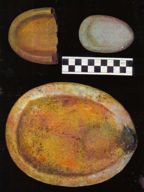
Plate 1: Lamps. Large 302, small 227, fragment 28.
Plate 2: Ulu Blades. Top to bottom, left 9, 205, 85; right 248, 330, 30, 71.
Plate 3: Flaked Ulu Blades or Unfinished Ulus and Ulu-shaped Scrapers and Saws. Left 161A, 347, 342, right 32B, 293, 204, 352, top to bottom.
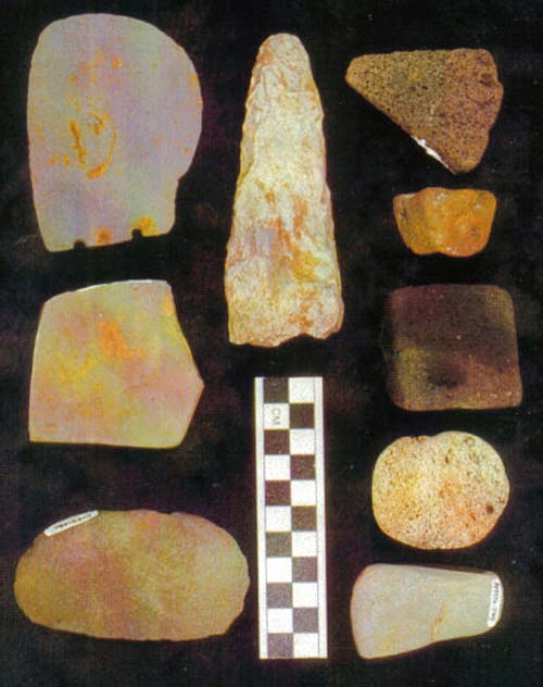
Plate 4: Flensing Knife, Tabular Hone, Pumice Abraders, Cobble Spall. Left 76 flensing knife, 120 hone, 246A cobble spall; center 168a flaked object; right scoria, red pumice 117, black pumice 94, white pumice, burnisher 249.
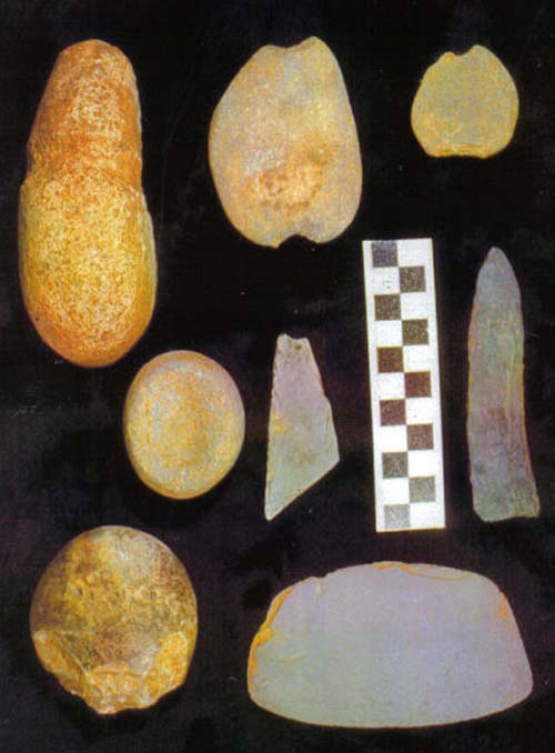
Plate 5: Various Objects. Top grooved cobble (around middle, over end groove does not show) 144, notched pebbles 376 and 349; middle row, miniature lamp 240, flaked slate blank 349, unfinished ground blade 305; bottom, hammerstone 157, ulu 264.
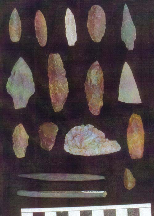
Plate 6: Projectile Tips and Chert Tools. Top, left to right, points 260, XX, 217, 129, XX; second row, points 126, 367, 227, 290; third row point 389, thumbnail scraper 340, sideblade 331, scraper 145; bottom, slate pin 242, slate rod 274, tool tip.
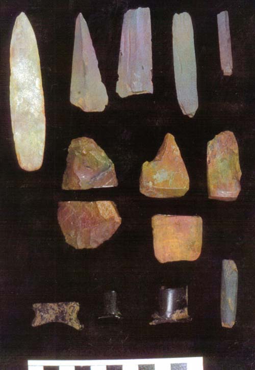
Plate 7: Slate Projectile Points, Adzes and Personal Ornaments. Top, from left, points 263, 356, 357,177, 338; second row chert biface 20, adzes 113, 88; third row pigment block 64, biface 65B, beads 281, 18, 282; bottom labrets 436, 220, 252, chisel 371.
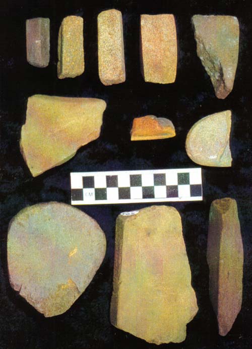
Plate 8: Whetstones and Hones. Top from left, bar-shaped 35, 120, 262, 246, vedge-shaped variant 75; second row, fine-grained variety tabular 295, sandstone rod frag. 197, split pebble tabular 344; bottom row flat tabular 247, 387, long triangular variant 10.


© Copyright 2018 Native Village of Afognak ~ all rights reserved