
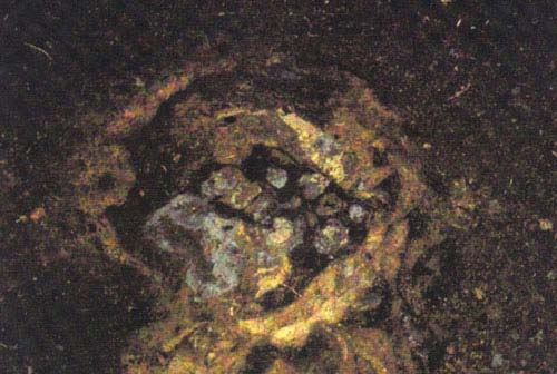
Pattern in a clay deposit near hearth in the main structure.
Donald W. Clark
September 2002
Prepared at Kodiak, Alaska, for the Native Village of Afognak
LITNIK ARCHAEOLOGY AT THE SALMON BEND SITE - 2002
INTRODUCTION
The Project
An archaeological excavation by the Native Village of Afognak and Afognak Native Corporation (NVA, ANC) was made at the mouth of the Afognak River at Litnik in 2002 as part of a continuing program for documenting Afognak history. The writer, assisted sequentially by Meagan Holms and John Ignatin, Jr., term contract employees of the Native Village of Afognak did the excavation. Young and adult participants in two Science Camp sessions also assisted. The NVA Dig Afognak camp at Katenai provided logistical support including camp facilities, meals, lodging and equipment and transportation.
Site Name
In State of Alaska Office of History and Archaeology records the site is designated as part of 49 Afg-010. Excavated sites usually are named. We have selected the name "Salmon Bend." The site along with others is located at a bend in the tidal reach of the Afognak River (Fig. 1) where at certain stages of the tide salmon are abundantly present. Numerous maul fragments for driving fish weir stakes and notched pebble weights from nets litter both shores of the bend, attesting to the former concentration of fishing activity there.
Summary of Results
The equivalent of twenty-two one meter-square units were excavated. These extended from the front to the back of a faint subrectangular house depression that was approximately 8 or 9 meters long and 6 meters wide (Fig. 3). They also include 5.5 square meters of a stone slab-paved "patio" at the front of the house and 5.5 square meters of a second room attached to the house. Cultural deposits were not deep, one or meter or less encompassed the house remains and occupational refuse from the floor to the base of the Katmai volcanic ash. More than 300 artifacts were recovered from the house fill and floor (the catalog includes additional items that are not implements). Most of these can be assigned to the house occupation. Implements are mainly ulu knife blades, which would have been used for cutting salmon, abraders and hones used to form and sharpen the ulus, projectile points, and notched pebble net weights. The composition of the collection suggests that the main activity was salmon fishing and processing. Artifact styles indicate that the site was occupied in the late part of the Kachemak Tradition, probably about 1000 years ago.
Previous Work and Selection of Site for 2002 Investigation
Archaeologists had considerable previous knowledge of the Afognak River and Afognak Bay area. Clark had spent the summer of 1951 at Rivermouth Point and in 1971 he and William Workman excavated parts of two Ocean Bay culture sites (4000 to 6500 years old) on the Afognak estuary. At that time an apparent transitional Ocean Bay-Early
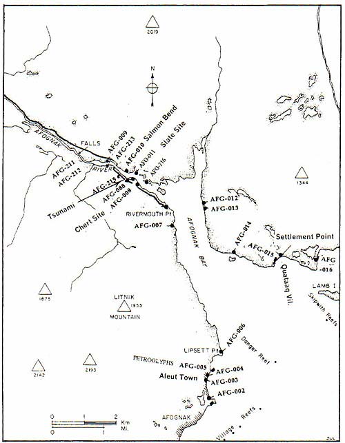
Figure 1. Map of Afognak Bay showing the location of old sites.
Kachemak site was located nearby. This was confirmed by test pitting and radiocarbon dating done in the 1990s by the ANC and the Canadian Museum of Civilization. These sites are located within one-third mile of the Salmon Bend site. Farther out on the bay, portions of a 1000-year-old terminal Kachemak midden at the Aleut Town site were excavated in 1999 and 2000 by the NVA. A Koniag tradition (ancestral Alutiiq) housepit village at Settlement Point was excavated by Patrick Saltonstall in the 1990s, and during the same period Katharine Woodhouse-Beyer uncovered the historic Creole Kataaq or Katenai village, also located at Settlement Point. These projects were part of the Dig Afognak Program. They included also minor excavation, by Megan Partlow, at a Koniag midden site located near the entrance to Back Bay across from Rivermouth Point. Survey done by the writer for the ANC in 1997 further identified the distribution or prehistoric remains along the Afognak River estuary. The late Kachemak tradition Tsunami site house was excavated there in 2001. This site is located directly across the river from the 2002 dig (Fig. 1, Fig. 4).
The Tsunami site produced results that varied from the nearly contemporaneous Aleut Town site, a mix of early and Late Kachemak characteristics for instance. Late dating, to about 1000 AD, of both the Aleut Town and Tsunami sites suggested that they were occupied near the end of the Kachemak tradition, and further, that the change from Kachemak to the Koniag culture (ancestral Alutiiq) may have been very soon thereafter and occurred rapidly (for culture history see Clark 1994). It was of some interest then that the results be confirmed and expanded. Directly across the river from the Tsunami site was another Late Kachemak house (so determined from artifacts washed out onto the shore). And this house in particular had a second room attached to one corner. Late Kachemak Houses are known only to have a single room though some investigators, who also had seen house pits with a room attached to one or two corners, had proposed that the corner annexes were a terminal Kachemak feature, one which led to the multi-room Koniag "octopus" house. The 2002 dig offered the opportunity to confirm that the two rooms were part of a single house layout, to date this architecture, and to determine if it belonged to a period of transition from Kachemak to the Koniag archaeological culture, estimated to be about 1200 AD.
GEOGRAPHICAL AND HISTORAL DESCRIPTION OF THE AREA
We refer to an Afognak River estuary. This is actually the tidal lower 13/4 miles of the river, otherwise not particularly estuarine in its characteristics. The extreme tidal range at the bay is 13 feet and it probably is the same at the river. As the tide runs in and out there is considerable exchange of water though it remains saline rather than brackish. The reach from just above the site out to the minus tide river mouth at Winter Island has a fine sediment or muck bottom. Near the site, both above and below, the bottom supports a heavy growth of eelgrass. It would be disastrous to attempt to wade across in this area. At low tide a gravel bar appears in the river 100 yards above the site and it probably is safe to cross there, though this was not attempted in 2002. From there to a point just above the abutments of the bridge that was washed away in 1964, the channel tends to be deep, even at low tide. In season large numbers of salmon congregate there. Farther up, the river widens. There, gravel bars are exposed at low tide while a "lagoon" forms at high tide. Water volume fluctuates greatly according to the stage of the spring meltwater runoff and wetness of the season. In some years, 2001 for instance, it drops to a mere trickle about two inches deep where not obstructed by rocks.
Three species of salmon, plus steelhead, enter the river: red (sockeye), silver (coho) pink (humpback) and the uncommon chum (dog). The red, silver and steelhead and many pink salmon continue to the lake to spawn. They run mainly during the summer months. Formerly the Afognak River was known for early salmon that arrived in April. Thus, salmon of one species or another were available at Litnik for more than half of the year. They were a major focus for subsistence. An Alutiiq fishing camp of 40 barabaras was observed here at the end of the nineteenth century. But the river is only in a second order of magnitude compared, for instance, with the Ayakulik River.
Sites of ancient camps with an antiquity extending back 7000 years ago line both sides of the tidal reach of the river. From this evidence, strong salmon runs may have been the norm in the era before commercial fishing. The red salmon escapement as of August 25, 2002 when the weir was closed was only 19,520. That figure would not be increased greatly by adding the commercial catch as the area was closed to fishing for most of the season. In better years the escapement through the weir has been between 25,000 and 131,000 red salmon, and runs of between 11,000 and 110,000 salmon of other species can be added (much of the variance is to be ascribed to pink salmon alternate year cycles). The commercial catch and salmon that spawn below the weir must be added to these figures. Roppel writes that the "sockeye productivity of Litnik Lake prior to the establishment of the hatchery is surprisingly obscure" (1982:232). Her discussion bears this out. No record was kept of the Russian period and personal use catches, but the number of yukola (dried salmon) credited to the odinochka at Afognak, plus a few thousand fish consumed fresh by the inhabitants of Afognak and Kodiak may be a close indicator. One early 19th century figure is 15,000 yukola; another is 27,000 but it may be for Little Afognak. Cannery packs of 25,000 cases, at 13 fish per case (i.e., 325,000 salmon), in part filled by salmon from other sources, could not be sustained and the canneries closed in 1891. However, the needs of a Native community of 200 persons comprised of the inhabitants of one large village or two smaller villages or several camps the size of the Salmon Bend site apparently could be met. They could have drawn most of their food for about five months from the river, that is, 30,000 person-days of food. This level of productivity should not have been difficult to obtain.
Today the site is surrounded by dense spruce forest, but there are clearings along the lower reaches of the river (Fig. 2). The forest has excluded poplar trees and alders. There were no spruce trees on Afognak when the site was occupied. Spruce is thought to have reached the island no more than 800 years ago, and Afognak Bay even later. The main source for timber would have been driftwood that was available on Afognak Bay beaches only a few miles from the site. In addition to the arrival of the forest, major environmental change affected Afognak Bay in the past, but most of this happened before the site was occupied. Some details are given in the author's paper "Afognak Before Russians: Precontact History of Afognak Village and Vicinity" prepared for the NVA.
Earthquakes and tidal waves did occur, and a tidal wave (tsunami) sand deposit was found at the top level of the house occupation at nearby Afo-215, the Tsunami site. Gary Carver's examination of boggy deposits adjacent to that site revealed that there had been at least five and as many as nine tidal waves both before and after the site had been occupied. Most undoubtedly were accompanied by earthquakes. There evidently have been changes in the level of the land, especially as indicated by studies by Carver, Crowell, Mann, and Saltonstall, and by the case in 1964 when the land dropped approximately six feet. The fact that the spatial arrangement of sites up the Afognak estuary starts with the oldest sites at its lower end and progresses upstream to historic sites located near the Fisheries weir, just below the falls, especially suggests changes in water level if fishing techniques remained unchanged.
In 1964 tidal waves inundated the site and deposited approximately 8 cm of sediment consisting mainly of reworked 1912 volcanic ash derived from the Afognak estuary or head of the bay. This created a distinct secondary tephra layer separated from the 1912 fall by a thin dark brown soil band.
Late winter ice on the river would have isolated the site from the open bay. A mile trek would take a person to the open coast, to collect shellfish or paddle farther out in kayaks on a sea mammal hunt or to fish in the bay waters. But it might have been more practical to move to a more temperate outer bay location. In very harsh years Afognak Bay froze almost as far out as Lipsett Point (Dennis Knagin oral communication to Clark August 2001).
The site has escaped damage from historic development. During the Russian period there had been a camp adjacent to the fishing hole up the river, and towards the end of the nineteenth century when two canneries had been built inside Rivermouth Point there appears to have been a fishing station at Litnik. The historic Litnik summer village was located in this area and upstream at the head of the lagoon. A fish trap or "zapor" and dwellings were built just above the limit of tidewater at the site of the Department of Fish and Game weir. The terminus of the early twentieth century tramway that ran up to the salmon hatchery on Afognak Lake was at the riverbank only a hundred yards from the excavation but the house site was by then protected by the accumulation of Katmai volcanic ash. (The tramway was replaced by a graveled road from Rivermouth Point, which passed on the other side of the river).
THE EXCAVATION
Operations in 2002. During the 57-day period of June 19 to August 13, 29 days of excavation were done. In comparison, 28, 28 and 22 days were available for excavation during each of the three previous seasons. The excavation was shut down one day initially because of rain, upon which a weatherport was erected over the principal area. However, little time would have been lost without the shelter because rain tended to occur during camp breaks. With the exception of the July Fourth recess, the writer remained at Katenai during camp breaks to clean and catalog the collection. The excavation was filled in under the supervision of Gary Knagin at the close of the season after Clark had left the field. Except for clearing the turf and underlying volcanic ash, which was done by shovel (Fig. 5), all excavation was done with small trowels. Sufficient personnel were not available to do screening.
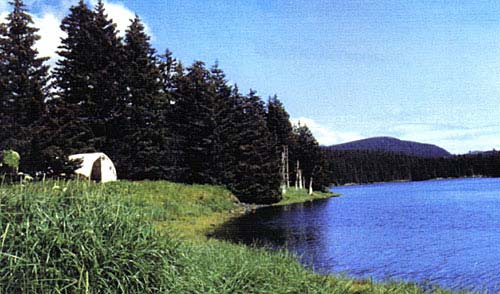
Figure 2. The front of the Salmon Bend site looking down the Afognak River.
In addition to being important as a support group, camp staff assisted the excavation in significant ways such as removal of turf from excavation units. Youth from the two Science Camps and two of the Science Camp mentors also helped with this task, with lugging away buckets of dirt, and sometimes in excavating. It was felt that giving them the opportunity to assist would increase their appreciation of the practice of archaeology, including its "grunt" tasks. However, few persons actually mastered excavation techniques and achieved the familiarity necessary for recognizing such features as house floors or how to know artifacts.
Although subsidence of a meter did not affect the excavation directly, it did result in erosion of several meters of deposits from the river edge of the site. Soon after 1964 the shore became paved with thousands of artifacts and pieces of fire-cracked rock and other stone from the site. It has been collected repeatedly and still yields the occasional interesting artifact, including, in 1200, a "breasted" stone lamp. These collections supplement and complement the excavation, and the excavation has determined that the artifacts on the shore belong largely to a single period of occupation, that of the Late Kachemak house.
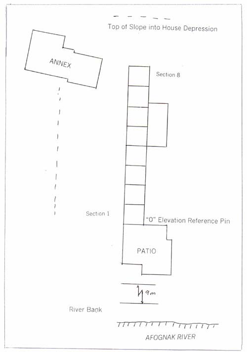
Figure 3. Map of the Salmon Bend site showing excavation layout.
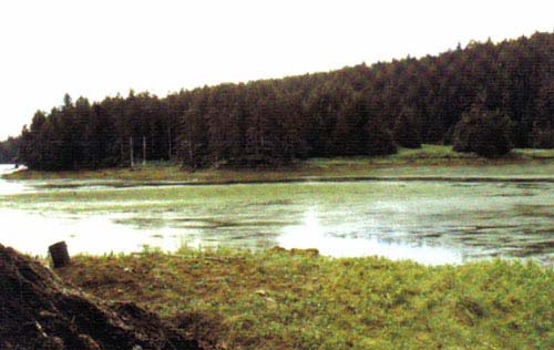
Figure. 4. Looking across the Afognak River at low tide.
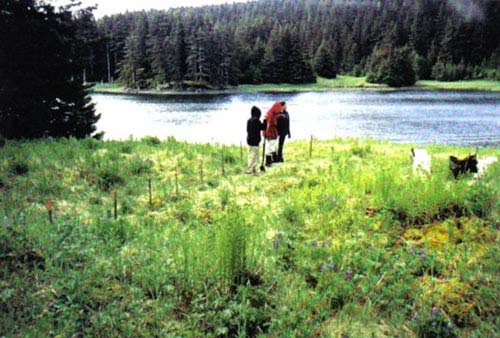
Figure 5. Opening up the site. The line of stakes runs the length of the main structure.
THE STRUCTURES
Main House. The primary structure was located in and probably helped form a deep sub-rectangular depression. Except near the front, where there was only a slight berm, the depression had sloping sides that apparently extended beyond the limits of the house. There was no rim or edge to define the actual housepit but the excavation established points at the front, at one side-wall and for interior hearth features. From that is estimated that the house was about 6 meters or 20 feet wide and 8 meters or 26 feet long without counting the entry. This is larger than Kachemak houses elsewhere, but because the limits are not sharply defined, these figures are subject to revision.
A one-meter-wide trench (locally expanded to two meters) was run from near the back wall to and through as slight gap in the berm near the front. The gap was thought to be a surface expression of the caved entry. Later, the excavation was extended towards the river to expose a feature termed the "patio" (Fig. 6, Fig. 7, Fig. 8).
Considerable slabby fire-cracked rock was found at a very shallow depth below a thin cover of black and dark brown soil. Most of the burned rock appeared as two mound or humps (in Sections 5-7). Underneath there were two hearths, fireplaces enclosed by slate slabs. The rock evidently had been heated for so-called sweatbaths, the Native equivalent of the banya. Whether the heated rocks were used in place or had been intended for removal to another location has not been determined. Excavation of the house area was too limited to identify a separate bath area. The excavation also exposed at a shallow depth many angular blocks of stones or small boulders. Their presence is perplexing, as they would have obstructed occupation of the house. (Later, when the excavation was expanded laterally by one meter in Sections 13-15, the fill and floor were found to be free of such rock.) Towards the front of the house (mainly in units 2-4), when the irregular boulders were removed there remained a layer or array of stone slabs, often more than one slab thick, well above floor level. On the down-river side the slabs were three thick extending into the wall beyond the excavation. They appeared to stop at the upriver edge of the trench, but due to the limited width of the excavation it was not possible to delimit this feature or to isolate it from other house features, which would have facilitated its interpretation.
Several post-holes, i.e., small round deep soft areas with different fill, were found in the floor. These were of large enough in diameter to have held substantial posts. The floor area uncovered was too limited for a pattern indicative of the form of house superstructure to be determined. It would have been some kind of post frame structure, but whether there was one or paired ridge poles, and whether posts were placed at the ends or more centrally and in an arrangement for supporting a cribbed roof is not known.
There is some discussion among archaeologists as to whether regular (winter type) houses were built at fishing camps or whether lighter structures were built, similar in outline but without heavy thatched roofs and turf walls. The Salmon Bend housepit lacks the sharp definition of a late Koniag (precontact Alutiiq) house, but this may be due to its greater age. Remains reached very close to the surface, to just beneath the 1912 volcanic ash deposit, which on the one hand suggests that it was not a heavily sodden structure. On the other hand, postholes of good size show that substantial uprights had supported the superstructure. Because of its location near the centerline of the structure, the trench would not have intercepted much material (soil derived from sods) slumped into the house pit from turf-banked walls. Further details not recovered from the limited excavation are desired. For instance we did not obtain a soil profile showing the intercept of the excavation for the house pit with the original ground surface, and thus we do not know how deep the house pit was. Enhanced by the soil cast along the sides from the original construction, it appears to have formed a significant depression, 70 to 80 cm deep as measured against the back berm. But the depth below the rise along the upriver side of the pit is only about 50 cm.
Soil layers exposed in the trench were as follows: below "Katmai" a thin zone of black stained soil, and then brown soil over a deposit of sand of about the same thickness (2 cm). Artifacts occurred almost to the very top of these deposits (as little as 2 cm below the 1912 surface). Thus, soil formation, including old volcanic ash falls and any turf and grass (later rotted) placed over the structure, added little to the burial of the site. These layers were underlain by the fire-cracked rock, hearths and hearth ash, or by clay features (Fig. 8) and dirty sandy soil. Considerable clay was placed around the hearths, probably to refresh ground dirtied from charcoal and to make basins for food preparation. The clay was dug into and more was added to renew or replace pit features, hearths were refurbished and raised, and stakes for cooking were driven into the floor and later removed. A mass of paisley-patterned orange, cream-colored, blue and charcoal stained variegated clay and soil developed. The two clay-lined features figured came at the beginning of this process. They are located directly atop glacial till hard pan. They would have been much deeper but the upper walls would have been destroyed during ongoing occupation of the area. The buildup of floor deposits is an indicator that some duration or continuing occupation is involved in the history of this house.
The succession of layers in the down-river wall one meter from the original trench is simple and is presented by text (next page).
The Entry and "Patio" of the Main Dwelling. A tunnel-like entrance passage, which would have survived in the form of an infilled ditch, was expected on the basis of excavations at Kachemak houses elsewhere (Steffian 1992). A large area paved with stone slabs was uncovered at and apparently outside the front of the house at only a slight depth below the 1912 volcanic ash (Fig. 9, Fig. 10). This feature may have extended beyond the 5.5 square meter area exposed, as we did not fully determine where the array of slabs stopped. There appeared to be a dipping angled edging row along one side, but the trend of these slabs does not match that of the house. Usually the pavement was one slab-thick but in a few places it was doubled. Some artifacts were found above the slabs. They did not differ notably from those found deeper or elsewhere in the site. In this stone feature there also was a well-rounded boulder (Fig. 15). It can be surmised that it was purposefully transported to the site from a storm beach located farther out on the bay. The boulder is slightly pitted on one face. The slabs were set on a layer of gravel and in one area, about three-quarters meter across, the gravel was several inches thick, evidently in order to fill a depression. This shows that construction of the "patio" was not a casual undertaking. But in spite of this apparent effort to create a pavement, the patio flagstones are quite uneven (Fig. 9). Possibly there had been later disturbance and slumping.
DOWNRIVER FACE OF SECTIONS 13, 14 AND 15
| Turf | |
| ---------------------------------------------------------------------- Secondary impure volcanic ash deposited by water in 1964 |
|
| ----------------------------------------------------------------------- Thin soil line of 1912-1964 |
|
| 25 cm total | ----------------------------------------------------------------------- 1912 Katmai-Novarupta volcanic ash |
|
____________________________________________________________
|
|
| 10 cm + | Black soil grades into... Brown and varigated grown soil |
|
____________________________________________________________
|
|
| 2 cm | Fine gravel (disappears laterally in the upriver direction) |
|
____________________________________________________________
|
|
| Many thin bands of brown, dark brown and black extending down to floor | |
| Traces of orange volcanic ash at some locations | |
|
--------------------------------------------------------------------------------------------------
|
|
| 48-50 cm below Katmai ash |
Glacial till hardpan floor |
A considerable deposit lay below the slate slabs. This included fire-cracked rock with charcoal-possibly an expedient dump for refuse cleaned out from hearths-as well as soil enriched by products of the occupation. Among artifacts fragments of ulu blades, hones or abraders and notched pebble sinkers were numerous. Further deposits had filled one end of a ditch or entry trench going to or into the house. Continued excavation uncovered this trench to its outer end, thus establishing the probable presence of a slightly sunken house entry. The depression was not deep enough to define a cold-trap type entry. There, too, a cache of 18 Norton-style arrow points was discovered. Some of the stone slabs had overlain the filled-in entry so it is surmised that the Patio is a late modification or addition to the structure, made at a time when the entrance noted above was out of service. It evidently had been filled in earlier during the course of occupation, as overlying slabs did not dip into any possible caved passage.
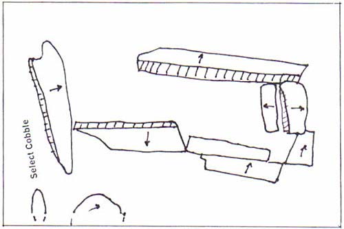
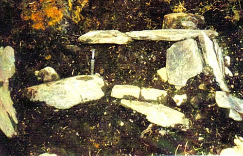
Figure 6. A disturbed stone slab hearth in the main structure.
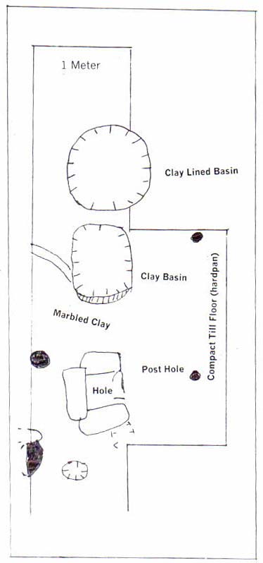
Figure 7. Drawing of features in the main structure.
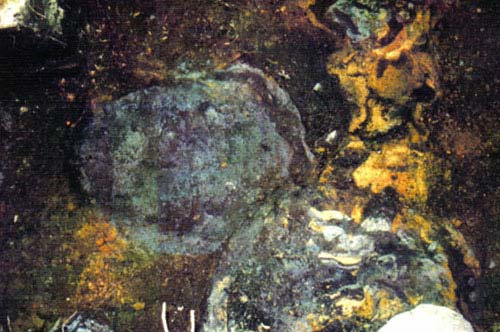
Figure 8. Base of a clay-lined basin in the main structure.
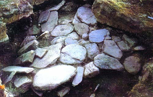
Figure 9. Patio slabs. Some slabs already had been removed from the entry area.
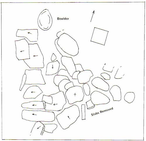
Figure 10. "Patio" slabs.
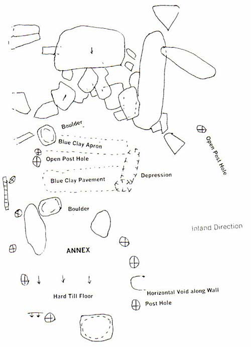
Figure 11. Stone slabs in the "Annex."
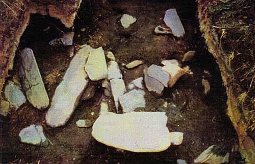
Figure 12. Stone slabs in the "Annex"
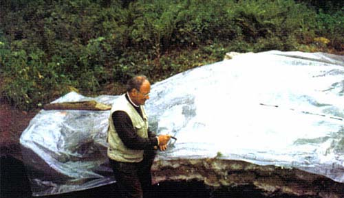
Figure 13. Clark retouching a 1-to-1 overlay drawing of the Annex features.
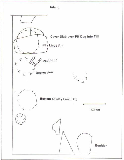
Figure 14. Some features below stone slabs at end of "Annex."
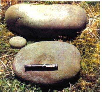
Figure 15. Two boulders found in the "Annex" and the "Patio."
The Secondary Dwelling. This feature, termed the "Annex" during excavation, is seen on the surface as a modest size irregularly bounded depression with highly irregular surface expression. A slightly depressed meter-wide gap in the upriver side of the main dwelling depression was thought to mark the location of a passage between the two residences. Excavation was oriented towards verifying that the irregular depression was a house feature and that the proposed passage actually was such. Initially two one meter sections were excavated to verify occupation and find the passage floor, but when a layer of overlapping slate slabs was uncovered the excavation was expanded to 5.5 square meters to fully expose the slabs. Figures 11-14 show the result. The slabs reposed at various angles, probably due to slumping of the original feature, but most slabs were horizontal or dipped only slightly. However, one of the larger slabs was highly inclined and its top edge was barely below the 1912 volcanic ash layer.
Continuing excavation after the slabs were removed revealed additional deposits with ash and charcoal from informal hearths, or from a hearth that wandered somewhat over time, two clay-lined pits, and two clay "aprons. There were a number of postholes mostly in two rows defining a passageway into the main structure. There also was a sideways or horizontally oriented void that appeared to mark the intersection of the passage with the upriver wall of the main structure. In most areas the final floor was glacial till hardpan. These features are shown in Figure 11. As well as the post holes, slumping wall deposits helped to define the inland side of the passage with steeply sloped bands of sterile soil and streaks of darker soil stained from traces of the structure. At approximately one meter width, the entry to the annex was wider than had been anticipated.
The reason for the numerous and sometimes large (up to 130 cm long-more than 4 feet) slate slabs is not altogether clear. Unlike the case at the "patio" they were not underlain by gravel and the slabs appear to represent excessive effort if their only purpose was to refurbish the structure with flooring. Conversely, they make a very heavy burden to be supported if the structure had been roofed with slate slab shingles. None was part of a slate box, a hearth enclosure or a burial crypt. For now their presence is simply noted for the record.
An elongate very smooth unmodified boulder was found in the fill just within the structure near the inner end of the passage. This object had been carried there in some problematical act, but very purposefully as it is quite heavy and likely came from a storm beach far out on the bay. One fissure slightly resembles a mouth, but examination of the object did not reveal any painted on features such as might have rendered it into a representation of a creature.
In ethnographic Alutiiq houses appended rooms, to a large degree comparable with the "Annex," were family quarters and sleeping compartments. They were kept clean, no fires were built in them and food was not cooked there. The Annex uncovered, but not completely excavated, at the Salmon Bend site obviously had seen numerous fires inside, although formalized stone-enclosed hearths were not found, and the two clay-lined pits and clay-surfaced aprons there probably were for food storage and preparation. This room was used essentially as a separate dwelling although it was connected to the principal dwelling. Floor elevations in the two are roughly concordant.
ARTIFACTS
For comparison, the artifacts recovered during each of the 2001 and 2002 seasons are listed in Table 1.
| TABLE 1: LIST OF ARTIFACTS | ||
| Identification | 2002 Salmon Bend | 2001 Tsunami |
| Stone lamp | 1+beach | 3 |
| Stone lamp, unfinished | 0 | 1 |
| Stone lamp, miniature | 0 | 1 |
| Ulu blade, complete | 10 | 19 |
| Ulu blade major fragment | 27 | 31 |
| Ground slate minor fragment | 68 | 79 |
| Ulu fragments total | 105 | 110 |
| Stone saws? | 15 | present |
| Tool slate | abundant | abundant |
| Flensing knife, fragment | 1? | 7 |
| Heavy flaked chert bifaces, unfinished | 11 | 3 + 2 lg. basalt in 97 |
| Flaked chert sideblades & small knife | 3 | 2 |
| Chert gouge | 1 | |
| Chert scraper, various formats | 3 | 3 |
| Grooved or notched cobbles | 5 | 5 |
| Notched pebble sinkers | 133 | 50 |
| Perforated pebble | 0 | 1 |
| Projectile tip | ||
|
14 | 12 |
|
10 & 17 in cache | 11 |
| Egg-shaped cobbles | 2+ | 7 |
| Small spheroids and ovoid pebbles | 20+ | 5+ |
| Cobble maul fragment | 8+ | 1 |
| Hammerstones | 17 | 10 approx. |
| Cobble spalls, utilized | 3+ | 6 |
| Cobble spalls, other | 43 | 20 |
| Adze bit | 1 + frag. | 3 + 1 in 19970 |
| Burnisher | 1 | 1 |
| Abraders and hones | ||
|
10 | 19 |
|
8 (+2?) | |
|
2 | 8 |
|
15 | 11 |
|
3 | |
| Ulu-shaped (stone sheet) scrapers | ||
|
12 | 17 |
| Labrets & fragments | 0 | 5 |
| Red pigment pebble | 2 | 2 |
| Iron mineral pebble | 2 | |
| Beads | 3 | 4 |
| Incised slate tablet | 1 | 0 |
| Slate pin bipoints and slender slate rods | 16 | 3 |
| Miniature grooved pebble | 1 | 0 |
| Flaked slate blank | 2+ | |
| Chert flakes | 242+ | |
| Total (without unused cobble spalls, chert flakes, spheroidal pebbles, hammerstones, egg-shaped cobbles, mauls, unground slate scrap) | 451 | 360 |
Lamps
Household paraphernalia is limited in the present case to stone lamps. One plain but well made lamp was found in an on-end position at one side of the "annex." Apparently, it had tumbled or had been tossed into the fill. It is of medium size, 6 inches long (15.5 cm). A large area within the bowl and on the exterior at the wick end is encrusted with char from burning oil. As well, at some time parts of the lamp had been daubed with red ochre. A second lamp of almost the same size was found on the shore adjacent to the excavation in 2000. It is of the breasted or female style. Although it is unlikely that it came from the same house, styles of artifacts from the shore and the excavation indicate that essentially the same culture period or occupation is represented in both..
Ulu Blades
Ulu blades tend to be oval to rectangular in shape, mostly the latter, with slightly convex cutting edges, ranging from straight to very convex. Highly arcuate or semilunar specimens are rare. Complete blades range from less than 3 inches (7.5 cm) to more than 6.5 inches (16 cm) long. Counting fragments, the ulus are roughly tied with notched pebbles for the distinction of being the most abundant artifact category. This attests to the importance of catching and processing salmon. None of the blades shows any feature to assist hafting: notched ends, deep angled notches in the back, tanged back, or a drilled hole. In this respect the Afg-010 ulu collection is one of the plainest or most impoverished of all those obtained from the Kodiak archipelago
Slate, Slate Blanks
Fragmentary sheets of slate suitable for fashioning into ulu blades and other ground slate implements were abundant. In some cases the slate evidently was naturally present from the breakage or unintentional splitting of slate slabs and beach shingles. Little of this material was collected. There also were tablets and blades of slate that evidently were in the process of being shaped into implement blanks. The occurrence of this material shows that tools were being made on the site. The occurrence of whetstones and hones also supports tool making, though the hones and abraders also would have been used for sharpening ulus and for finishing the surfaces of wood and bone implements. Slate for manufacturing tools was readily available at Afognak Bay.
Some slate was being flaked also into narrow elongate or leaf-shaped blades. In one example the faces of the blade are ground to a finish but the flaked edges are still blunt. In all such cases it is a matter of judgement as to whether these items actually had been intended for finishing to sharp edges or whether they had a use in their present form.
Flensing Knives
These are elongate knives that are sharpened on both edges (sides) as well as around the unpointed distal end. This knife format is recognized in one rounded end fragment and one basal fragment with two drilled holes. The perforations show the careful Kachemak mode of drilling in which the two halves of the perforation, drilled from opposing sides of the tool meet perfectly with little taper within a slightly biconical hole. It was proposed earlier (Clark1974) that this was accomplishing through drilling to the extent that the hole just began to break out on the opposite side and then the implement was turned over and the hole was "back drilled" from the second side. These knives commonly break across the base through the perforations. That is less likely due to weakening from the perforations than to the fact that this is the point of juncture between blade and haft.. The drilled blades tend to occur more in early than in late Kachemak times, thus recovery of only one specimen supports late dating of the site.
The small stemmed knife with spatulate blade figured in the plates is not counted as a flensing knife as it is small and delicate.
Flaked Side-blade Knives
A single slightly asymmetrical thin well-prepared leaf-shaped biface knife (flaked to shape on both sides or faces) is made of basalt. It is 8 cm (3 in) long. Tools of this format were mounted in the side of an elongate handle, hence the term "side-blade." They are most characteristic of the Bering Sea region and northward 1000 years ago and earlier.
A 6 cm-long basalt side-blow flake (wider than long) is sharpened along one edge and rudimentarily shaped, probably for use as an inserted side-blade.
Chert End-blade Knives
The well-fashioned symmetrical blade with rounded end and cutting edge would have been inserted into the end of a handle. It is 4.5 cm long. This format also is common in the Bering Sea region 900 years ago and earlier.
A second bifacially-prepared knife blade has a pointed end. It is 5.5 cm long-little over 2 inches-but half the blade would have been enclosed within the haft.
Chert Scrapers
Formally shaped chert or flint scraper bits are absent from the collection but there are a few pieces that appear to have been used as scrapers. One is a snapped flake that has been used at the snapped edge. The edge is retouched (small flakes removed either intentionally or from use) giving the edge a slightly concave form.
The edge of a long basalt flake is worn smooth at the end.
A small 3.7-cm-long flake has been flaked on one surface to a tip and one edge to a bevel (Fig. ). It appears to be a specialized form of scraper used at the bevel. The tip is too delicate for gouging or boring.
Another small flake was retouched along one side. It would be termed a side-scraper.
The final piece is a roughly fashioned small (2.7 cm) loaf-shaped object that bears a short, narrow beveled edge at one end, which may be the result of use as a tool bit.
Fishing
Fishing artifacts were limited to weights for nets and lines. The probable line weights are cobbles in the size order of 9 to 11 cm long 9 4 inches more or less. Three specimens have short grooves or notches at the two ends (or sides); one has a partial or unfinished groove around the middle; and the fifth fragmentary object has a groove around the middle and over one half meeting this encircling groove.
The notched pebbles, which number 136 examples, vary by a considerable degree in size and degree of preparation. Specimens found in a cluster of 31 average 40.2 g in weight 9 somewhat more than an ounce, which is light compared with other collections of notched sinkers from the Afognak River. Their length falls between the extremes of 4.1 and 7.5 cm. The remaining 105 are between the extremes of 3.3 and 11 cm, though these are outliers atypical of the average length, which is in the vicinity of 7 cm. Their average weight is 56 grams. A smaller sample from across the river excavated in 2001 weighed on the average 60 grams.
Notched pebbles bear a battered and sometimes smoothed notch at each end and, in one case, at the two sides and rarely at one end only (unfinished?). In some cases preparation of the notch is minimal, a slight battering, otherwise there is a well formed small notch, but sometimes there are large deep notches and in a few cases there are very broad shallow notches that extend across the end of the pebble. Similar variations also are found in notched sinkers from other Kodiak sites, from Karluk for instance. The might be individual styles of different fishermen, but all are found together.
There can be little doubt that they were net weights, and that the fish to be caught were salmon. Herring also appear in Afognak Bay to spawn, but their spawning habitat reportedly does not include the Afognak River up as far as the site. Nets probably were used directly in front of the site. They could have been either seines or gill nets. The mode of use may be related to water depth, and if as seines, which is less passive than gillnetting, to the stage of the tide at which salmon are most abundant in front of the site which has its particular water depth. Prior to subsidence of the area in 1964, the local water depth was little more than one or two feet, essentially the depth of the river, at minus tide, to nearly 14 feet at an extreme high tide. It appears that traps were used concurrently with nets, probably under different water conditions or depths. Webbing could have been used for trap walls and weir fencing but in this case it would not have been necessary to weight the nets with pebble sinkers.
Maul Heads
Inferential evidence for weirs, i.e. driving of weir posts and stakes, comes from the large number of maul heads or giant hammerstones found on the shore on both sides of the river and in the site. Usually they are broken and battered, which suggests harder usage than was envisioned for driving poles into the river sands and gravel. Some thus might have been used to knock spall tools (boulder flakes or cobble spalls) off large cobbles. No grooved maul heads were recovered. The common maul head was a large slightly flattened ovoid cobble, usually slightly pitted on the two broader faces, probably to hold wedges that tightened lashings that secured the head to a handle. Sometimes the maul also had an indentation on each narrower side (or all four sides if there was no differentiation). One relatively complete example was found in the main room. It is slightly smoothed on one side, showing that once it also had been a grinding stone, possible an ocher grinder recycled from an earlier site.
Weapons: Projectile Points
Only the stone tips of weapons or hunting implements were recovered due to the decay of wood, bone and antler. They were used to tip spears, darts, and arrows and sometimes at the end of harpoon heads, but in some cases it is difficult to determine for for which application each specimens was intended. Each one is described in Table 2.
| TABLE 2: PROJECTILE POINTS | |
| Ground Slate No.* |
|
| 13 | Heavy lance midsection, cut line on one face, an Ocean Bay II form. 3.0 cm wide. |
| 61 | 202, 292, 310, 316, 386, 389, 397 knife?, 413. 8 varied fragments. 389 has blunt edges and may be a stem. |
| 39 | Barbed and stemmed (both broken), broad body, indicators of having been made on a flaked blank. |
| 203 | Complete but poorly fashioned thin willow-leaf shaped blade with blunt edges near the tip, 5.2 cm long |
| 273 | Especially well made, length without stem (which is broken): 9.5 cm. The undersides (inside) of the barbs are sharpened, i.e. beveled to an edge, whereas in otherwise similar barbed points the inner edges of the barbs and adjacent stem have been squared-off (flattened). |
| Beach | Barbed rod or pin (variant of slate pin or "awl"?) |
| --- | Small barbed rod or pin (variant of slate pin?) |
| Slate Pin or "Awl" Group | |
| 19 | Nearly complete, 10.7 cm long, long taper to pointed end, plain butt |
| 40 | Fragment, sharply pointed |
| 48 | Pointed fragment |
| 71 | Pointed, 8 cm long, plain butt end |
| 72 | Complete, flat rectangular cross section, plain but end, 6.6 cm long |
| 73 | Fragment, midsection |
| 74 | Fragment, ends broken, split in half lengthwise, originally large |
| 204 | Midsection fragment |
| 205 | Midsection fragment |
| 206 | Unfinished or rudimentary fragment, small, one end has a wedge bevel |
| 209 | Tip fragment |
| 265 | Fragment, pointed end, diamond-shaped cross section (only one this format) |
| 266 | Fragment, midsection, broken by end impacts? |
307 |
Fragment, unfinished |
| 311 | Slender, short 4.6 cm, damaged both ends but this has not reduced the length, one end sculptured to a stem, the other end beveled to a wedge part of which has been lost to breakage. This specimen appears to be a tool bit. It is not possible to convey the details in an ordinary photographic plate. |
| 312 | Fragment, heavy and large, narrow wedge termination, broken by end impact? |
| 349 | Midsection fragment, slender |
| Flaked Stone | |
| 64 | Tip end fragment, basalt. The material and workmanship are suggestive of the points in the "Norton cache", at 12.5 mm wide, it is in the range of those points, which in the body are up to 13 mm wide. This specimen came from the "Annex" but at a shallower depth than No. 154 (26 vs 40 cm). . |
| 233 | fragment, red chert, slightly asymmetrical, could be a side-blade |
| 44 | Misshaped stemmed red chert point |
| 70 | Stubby blade, red chert, small 20 mm long, 5.7 mm thick, from the shore |
| 154 | Norton-style arrow tip, basalt, faces ground, 50 mm long |
| 230 | Short, yellow-brown chert, slightly shouldered ed square stem, slightly concave base, thick 6 mm, 27 mm long. |
| 231 | Square-stemmed point, small, basalt? Slightly asymmetrical, 31 mm long |
| 267 | Well-prepared chert point with tapered stem, 63 mm long |
| 415 | Norton-style points, cache of 18 and fragment, half have facial grinding, length 59mm to 73 mm, most are close to 70 mm; width above base 11 to 13. Flare at the basal "ears" adds some to the width. Bases are concave and symmetrical except one with slightly convex base. Their symmetrical form distinguishes these points from other related Norton-Ipiutak styles including points from Chirikof Island. |
| *Prefix with "AM451." | |
The slate pins or so-called awls also are described there under the assumption that most of them were projectile tips, but it is very apparent that some if not all of these slender slate rods actually were tool bits.
Blunted Stone Sheet Saws
No large blunt ulu-shaped scrapers were recovered but there were three probable flaked slate ulus and a few fragments with sharp edges.
Many additional small rectangular slate sheets and fragments have chipped blunted edges. In most cases the stone is coarser grained than the slate used for ulus, thus presenting a rough texture suitable for scraping and sawing. All these are interpreted as scrapers or as saws used on stone and bone.
Slate Pins
A bipointed pin 7 cm long was found two years earlier on the eroding river shore. Sixteen more or less similar rods or pins were excavated. They very considerably in detail of size and termination, as is described in Table 2, though only two are complete. Most of them are broken, and this leads to the supposition that the use to which they were put, probably in most cases as projectile tips, preferred that they break (in a wound?). Some, however, appear to be tool bits. This artifact occurs widely in Late Kachemak sites but in a frequency that would have lead one to expect recovery of only a few specimens in 2002.
Egg-Shaped Cobbles and other Natural Stones
Examples of spherical, oval and elongate rounded pebbles and cobbles were collected but additional unmodified pebbles and cobbles were discarded to avoid placing a strain on the curation facility. There were no clusters of large pebbles and cobbles that could have been used for cooking, especially for stone-boiling technique. They may have been foreseen for later use as mauls, hammers, grooved cobble weights and wrapped (unmodified) weights and children may have collected some as play things. A very conscious effort was made to collect these very rounded stones as they are not available locally. They would have come from high-energy beaches located farther out on Afognak Bay.
Hammer-stones
Hammer-stones bear surface areas crushed or pulverized from impact. Such use traces vary from slight to extensive modification at the ends and elsewhere. All of the obvious hammerstones, which were not numerous, were collected. They would have been used for the initial stage of flaking chert for implement blanks, to peck notches and grooves in pebble weights and grooved stones, to strike cobbles to detach large clam-shell-shaped spalls (boulder flakes), to hollow and shape stone lamps, and to shape blanks for adze bits (uncommon) and slate blades. Some probably were hafted and used as club heads and to drive bone and wooden wedges. Others were held by hand.
Their form ranges from battered pebbles of irregular to elongate to rounded shape, to heavy elongate cobbles 20 cm long and weighing up to 1 kilogram. The largest specimen (AM 461:119) is slightly worn on one flat face possibly indicative of use as a grinding stone (i.e., a mano, not as a whetstone)
Cobble Spalls
Cobble spalls are a universal tool. They are large clam-shell-shaped flakes struck from rounded cobbles. The result is a tool with a sharp edge and thick easily held thick back. Striking the cobble, which required considerable force, did not always produce a well-formed spall, so often there is much cobble industry waste in site deposits. The popularity of this tool varied through time and from place to place. Locations without a local source of cobbles sometimes produced equivalent tools in an alternative mode from thin slabs of stone. In the Early Kachemak tradition, the spalls were shaped for use as scrapers and even as adze bits. Boulder flakes served for a variety of tasks: as hide scrapers, fish cleaners, to saw slate and other materials, to scrape wood and for narrow-edged chipping hammers. Those used as saws (mainly a late Ocean Bay application) and intensively as scrapers wear to smoothed edges. Usually a spall bears an impact scar or crushing at the thick back from the blow that detached it. They tend to be longest in the width dimension, from side to side. Typical specimens are 9 to 13 cm long, though some are larger or smaller. The assemblage was examined for shaping or modification of edges and also for smoothing that could be a result of use. There was very little material of that nature, yet it is evident that numbers of cobble spalls were produced for some purpose at the site. Three small specimens are smooth at the edge, probably from use as scrapers or saws. The largest specimen, which was found at the edge of a clay-lined basin, is of a size that places it apart. It is 15 cm (6 in) wide and has a broad bluntly battered back so it can be held conveniently. Chipping along the edge is a sign of use.
Adze Blades
Adze blades are represented by a small, complete, sharp specimen. It measures 5.7 cm long (2 1/4 in) by 2.8 cm (1 1/8 in) wide. The blank for the bit was flaked to shape. A second bit with a sharp bevel was completely formed by grinding. It is a longitudinal fragment.
Burnishing Stone
A 6-cm-long tabular pebble is worn flat on one edge. It fits the defining criteria of burnishing stones, which are thought to have been used to smooth and polish wooden implements through rubbing with pressure.
Whetstones and Abraders
Whetstones, hones and abraders occurred in a variety of shapes and types. They probably were used for shaping, smoothing and sharpening slate to form ulu blades and other slate tools and to finish wood and bone manufactures. The following description is tailored to the present collection but it probably also applies generally to Kodiak.
Pumice Lumps. Ten small unshaped pumice lumps, 2 to 5 cm wide have surfaces worn flat from use. Frequently Kachemak tradition pumice was red-brown colored, but white pumice also was found in 2002. People selected this material from a natural distribution that floated to the local shores and it is noteworthy that the reddish color occurs infrequently as part of this distribution.
Sandstone Whetstones and Hones. Other whetstones and hones are made of sandstones and siltstone of varying degrees of fineness. The distinction between whetstones and hones thus is somewhat arbitrary. Two typical example (illustrated) are 6.5 and 5 cm long. Split flat pebbles and sections from flat sandstone pebbles and cobbles, often recovered as fragments, are worn flat on one or both faces. These are larger than the rectangular bars and are up to 11 cm long. Fifteen whetstones can be placed in this group. They are mostly medium and coarse textured.
Bar-shaped Whetstones. Small sandstone bars usually are common in Kachemak sites but only one tiny example and the fragment of a larger one were recovered.
Flaked Chert Industry
Projectile points and scrapers and knife blades flaked from the flinty rock "chert" and basalt (preliminary identification) have been described individually. Several hundred red flakes and shattered pieces of red chert and a large core chunk were recovered. We count 21 implements of red chert. In addition, there are 9 artifacts of basalt and 1 of mustard-yellow chert. There were hardly a dozen flakes of other material. The three yellow chert flakes are very distinctive but those of drab basalt easily would have been overlooked and thrown out. The total of 31 flaked implements (not counting a cache of 18 Norton arrow points) compares approximately with the recovery of 25 chert and basalt implements at the Tsunami site in 2001.
The fractured red chert comes from Afognak Island, from Raspberry Strait, Malina Bay and the headwaters of the Marka Bay creek, thus large quantities were readily available. (The mustard-yellow chert is thought to come from the Alaska Peninsula.). A large quantity of this flawed material had to be processed to obtain blanks for finished implements. More than 500 flakes and pieces of shatter came from the Tsunami site. The number from the 2002 excavation is less but is not known closely because of collection improprieties by one of the staff.
Personal Ornaments
Labrets. No labrets (lip plugs) were recovered. This is surprising considering that they were relatively common at the Tsunami site and at Aleut Town. Their absence may be due to the randomness of archaeological recovery.
Beads. Two fragmentary rectangular beads are made of a soft salmon-colored or terracotta red stone that is thought to have been obtained from Kachemak Bay. This material was sought by Kachemak tradition people living on northern Kodiak. The rectangular shape probably is due to their being unfinished. A fragment of a probable pendant of the same material also was recovered.
Pigment. Two heavy pebbles of an iron mineral, arsenopyrite probably, are heavily encrusted with corrosion. One bears two flat facets, probably the result of rubbing the stone on a palette to produce pigment. One small red pebble has a ground flat surface. It may be the residual nub after the pebble had been rubbed away to produce a red pigment powder.
Incised Tablet
The small fragment of slate sheet with incised design (Fig. 16) is of especial interest inasmuch as such objects are rare in Kachemak tradition sites. One incised stone that also has wavy lines was found in the Late Kachemak Aleut Town site. Some from Prince William Sound may be of similar age. In contrast, incised pebble figurines in a different design format are common in Koniag tradition deposits.
COMPARISONS AND INTERPRETATIONS
The Question of More than One Occupation at the Site
The reach of the Afognak River investigated was an optimal location for occupation by precontact fishers. It turns out though, that occupation there was largely limited to Kachemak times 800 to 3800 years ago. Koniag Alutiiq and Russian Alutiiq occupation was farther up the river. Ocean Bay (before Kachemak) occupation was just downstream from the site. Each culture tradition has distinctive artifact styles and preferences, though each also has a lot of ubiquitous material such as hammerstones, cobble spall tools, abraders worn to shape, and nondiagnostic fragments of ulu blades and slate points.
Koniag occupation of the grounds can be excluded on the basis of the failure to find certain indicator artifacts such as numerous rudely formed greenstone adze bits and large grooved splitting adzes.
Five items are diagnostic of the Ocean Bay tradition, especially the slate-working phase of that tradition which ended about 3800 years ago (3500 in terms of unadjusted radiocarbon dates). One is the midsection of a heavy slate lance. The others are pieces of slate bearing saw cuts, a blank in one case, cut-off scraps in other cases. Slate was sawn like bone or wood with sharp cobble spalls and chert chips. Sawn blanks then were scraped for edging and final shaping and then finished by grinding and honing. No pieces showing the intermediate stage, of further shaping by scraping, were recovered. Similar technology was used to work slate at the beginning of the Kachemak tradition, until about 3000 years ago, but these items were wholly unexpected in a Late Kachemak context. A possible source for these items is the Late Ocean Bay village and transitional Kachemak fishing camp located, respectively, a few hundred yards below and across the river from the Salmon Bend site. It is likely that someone from those camps spent a few days camped at the Salmon Bend site. Material they left behind could have become incorporated in sod later used in the house walls. One eroded locus of Afg-010 farther upstream had a few exposed Ocean Bay-type slate blades in 1964, but extensive beach collections show that there was no noteworthy Ocean Bay occupation at the site. A single primary period of occupation is present at the site. Artifacts found on the shore, representing the whole site, correlate well with those from the excavation.
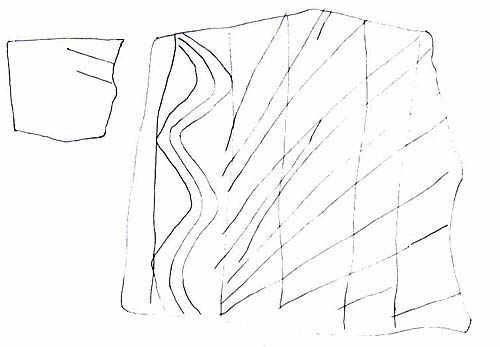
Figure 16. Incised tablet, enlarged and (back side) natural size.
Comparisons with Interpretations
Kachemak Tradition. It is proposed that the site was occupied during the Late phase of the Kachemak cultural tradition. The Salmon Bend site, which lacks bone preservation, only partially illustrates Late Kachemak culture. To give a more complete picture, we further describe this phase of Kodiak's past as has been determined from the investigation of numerous archaeological middens. Three sequential archaeological traditions are recognized on Kodiak (Clark 1994). The first one Ocean Bay, has a distinctive flaked stone and sawn and scraped slate technology. About 1900 or 2000 BC (calibrated age) the Kachemak tradition developed, probably as an outgrowth of Ocean Bay. This is a basic old North Pacific culture with strong ties to Paleo-Eskimo cultures of the Bering Sea region and with the Aleutian Islands. By about 1200 AD Kachemak had become the Koniag tradition, which basically is the ancestral culture of the Alutiiq people, encountered by the Russians in 1763.
Early Kachemak appears to be a Spartan, utilitarian culture, but interpretations of it are biased because artifact recovery is limited largely to stone tools. However, some bone was found at Kachemak Bay by deLaguna (1934) and possibly at Malina Beach, which has yet to be described. The stone tools originally were only a small part of the Kachemak set of utensils. Late Kachemak was more elaborate with much attention given to ritual treatment of the dead, to personal adornment, a profusion of labrets, and stone oil lamps that expressed male and female deities. Kachemak made great use of grooved cobble and notched pebble weights, probably for fishing lines and nets. The broad, single edged ground site semilunar knife or ulu, a hallmark of Eskimos, gradually became common. Double edged blades, some shaped like daggers, others sharpened around the rounded end, called flensing knives, also were used. Toggling harpoons first appear on Kodiak.
For the period of about 300 BC onward, elements of art, ceremony and decoration become commonplace in collections. There is better preservation of bone (and antler) artifacts. Recovered tools now include delicate eyed needles, wedges, harpoon heads and harpoon sockets (at end of the shaft to hold the head) in various styles, arrow heads, fish and bird spear prongs, fish hook shanks and barbs, and fish effigy lures. Adze blades and sockets (to attach blade to a handle) are known, but the blades are small, though well fashioned, and are not numerous compared with their abundance in Koniag times, possibly indicating less heavy wood working. Stone technology relied overwhelmingly on ground slate, for ulus and other knives and weapon tips, though some items were still flaked from chert in Late Kachemak times, more so on Afognak Island than on Kodiak. Ornaments, used mostly as jewelry, included stylized and naturalistic human and animal figurines, the labrets, and various beads made from jet (coal), amber, shell, ivory and a red stone from Kachemak Bay. Exotic materials were imported. There also were nose rings and pins and elaborately carved ornamented pins, possibly used to secure clothing. Stone lamps became large, up to 90 pounds, and sometimes portrayed bears, whales, humans and female breasts with evident religious intent.
Kachemak houses are best known form Steffian's excavations (1992) of a Late Kachemak site at Uyak Bay. These had below-floor-level (cold-trap type) entrance passages on one side, half to fully the length of the rest of the house. The single rooms tend to be 13 feet square with a central stone slab hearth, which contrasts with later multi-room Koniag houses. Many houses had small to medium-size clay-lined pits built into the floor, and also clay aprons around the hearth.
Comparisons with other Sites of the Kachemak Tradition. There are a number of Kachemak assemblages (collections) from Kodiak with which the Afg-010 collection can be compared. The objective of comparisons is to determine if the 2002 site is typical or whether it is variant or regionally different. We also would like to see what technology is associated with the situation of the site at a salmon fishing station.
The incidence of flaked points is out of keeping with their relative scarcity in Late Kachemak, an enigmatic occurrence in one group of Uyak site houses excepted (Steffian 1992) and also exceeds their incidence in Early Kachemak components where there is at least a modest amount of flaked stone. There is tentative evidence from surface collections at the Afognak River and from an excavation by the State of Alaska Office of History and Archaeology on Shuyak Island, as well as from Cook Inlet, that in the northeasterly part of its distribution the Kachemak tradition had a much stronger flaked stone industry than it did on parts of Kodiak Island.
Also missing from the site on Afognak but for one example are stemmed (often serrated) double-edged knives (broad flensing knives excepted). Such blades were common at the Early Kachemak Old Kiavak site (Clark 1996) and at Late Kachemak Three Saints (Clark 1970), present also at the Uyak site (Heizer 1956) but, not very common at Crag Point and essentially absent at terminal Kachemak Aleut Town (Clark 2000). Their absence at Afg-010 is not to be laid to the age of the site but appears to be a geographic variant.
Recovery of notched pebbles meets expectations. Modified cobble spalls often are a feature of the early phase of the Kachemak tradition. The moderate recovery at the two Litnik sites, with only a small number of specimens that appear to have been utilized, and the absence of extensive modification or reshaping of the spalls, argues for a change in the cobble industry from Early to Late Kachemak times. A contributing factor, though is that the site at Litnik has no immediate source of well-rounded cobbles.
The situation with adze blades at the Litnik sites is similar to that common to Kachemak tradition sites elsewhere on Kodiak-fewness, small zize and well-finished faces.
The Salmon Bend and Tsunami sites are fundamentally similar though certain artifact types were more common at one or the other sites (Table 1) and labrets were found at the latter only. Architecture may have differed between the two, and the Salmon Bend house is larger, though it remains to be seen that the two house pits at Tsunami were not connected by a sunken passage.
Notable differences observed at the Salmon Bend site (and also at the Tsunami site), compared with the rest of Kodiak archaeology during Kachemak times are i) a greater reliance on flaked chert implements of many classes, ii) a low incidence of barbed ground slate points, iii) absence of serrated-stem and lugged-stem double-edged knives, and (iv) a differing house form. Inasmuch as these differences are found at two sites, in both the 2001 and 2002 excavation we believe that they indicate the existence of a local variety of Late Kachemak culture on Afognak Island. Test pitting and surface collecting from eroded shores at Litnik shows that Kachemak occupations there in general used a lot of chert, did not have the knives mentioned, but barbed spear heads are known. The local regional situation is not that simple, though. Out on the bay, at Aleut Town, which dates to about the same period as the Litnik sites, flaked chert is very rare but barbed slate points (Three Saints mode) are common. Farther across Marmot Bay at Crag Point on Kodiak we find a similar situation (some barbed slate points, chert is in early occupations but uncommon in Late Kachemak). One possible explanation is that a different tool technology was preferred at the fishing camps, at the Afognak River mouth. This explanation is not very satisfactory. There is no particular reason to prefer chert (and basalt and other flakeable stone) knives, projectile tips and scrapers at the river fishing camps over their use at coastal sites. And the materials chert and slate were equally available at both. We do know, on the basis of beach collections made in 1964, that during the Koniag tradition occupation of Litnik (probably from 1200 AD onward) chert tool making and use and stopped entirely. The question (of why the site assemblages are different) is open for further discussion and the input of additional information. One forthcoming source of information will be the Late Kachemak inventory for Malina Creek, an excavation done 8 years ago but not yet analyzed. The site, referred to as Malina Beach, was an important salmon fishery but probably offered subsistence opportunities for year-round occupation.
The Norton Point Find. When Shaun Price found the first concave-base Norton style arrow point it perked considerable interest: on his part because of the niceness of the projectile, and on the writer's part because of the knowledge that this style of point was characteristic of the Bering Sea region, including the contiguous shore of the Alaska Peninsula, 900 to 2000 years ago. They belong to what is known as "Norton Culture," named after finds from a site on Norton Sound (Giddings 1964). With the exception of Chirikof Island, Points like this had not previously been known from the Kodiak Archipelago. We envisioned trophy collecting, whether voluntary or involuntary-return from a raid to a village on the Naknek Drainage or farther west on the Bering Sea shore of the Peninsula. Or perhaps a visitor, a trader, from there.
Late on the next-to-last day of excavation Clark was troweling out fill from what was developing into the main house entry trench when he uncovered another slender lanceolate point. While the boat was waiting to return to the base camp, another and another point was uncovered, lying at the bottom of the entry on glacial till. The next morning the excavation was extended with the recovery of more points, and several buckets of dirt from the preceding day's excavation were water-screened. Eventually 18 points and a fragment were recovered from the entry.
The first find was made in the secondary structure called the "Annex," and it helps to tie the annex to the main structure where the others were found. Although three points were found broken, they do not have the appearance of having been trampled. The points do not appear to have had a history of being under-foot at the entry, so how did they get there? The soil fill in that area showed the characteristic sloughing in or caving of material from the sides-plunging layers of crumbly disturbed glacial till interspersed with thin faint layers of stained soil-any explanation that the points had tumbled in from the sides has to take into account the fact that some of the points were lying on undisturbed till hardpan and most were still tightly clustered as if they had lain in a box. Earlier, in the description of the "Patio" it was noted that the entry passage apparently no longer was used when the overlying Patio was constructed. Possibly, while it was still a chamber open at least from the interior of the house the entry tunnel was a place to cache or hide important paraphernalia. They were contained within an area about 15 cm across and 30 cm long. In any case, the owner of the Salmon Bend house possessed weapons different from those of his contemporaries on Afognak. Dumond (1981) found a similar point in the Naknek drainage, and it may be assumed that the Afognak owner had traded with a counterpart from that area. Whether this happened at one or the other's home village or at a rendezvous on the Shelikof Strait side of the Alaska Peninsula is open to speculation. (Travel distance to Chirikof Island where similar points were used is much greater.) The uncommon occurrence of mustard yellow chert, again found in both the main house and the annex, leads to similar conclusions.
Cultural Placement and Dating
Types and styles of artifacts recovered that the site belong to the Kachemak tradition, to Late Kachemak in particular, within the Kodiak sequence of Ocean Bay, Kachemak and Koniag (ancestral Alutiiq) cultures. Two radiocarbon dates have been ordered, but with the detail already known and dated for the Afognak Bay area it should be possible to form a good estimate of the age and place of the Salmon Bend site within the Kachemak tradition without radiocarbon dates. The following characteristics lead to interpreting the site as have been occupied very late, probably between 800 AD and 1100 AD within the 100 BC to 1100 AD span of Late Kachemak.
Recovery of a late Norton style of arrow tip, used on the Alaska Peninsula around and shortly after 1000 AD but earlier farther north.
Pale red beads
Wavy lines on an incised stone tablet, a motif also found on one tablet from the terminal Kachemak Aleut Town site, otherwise uncommon on Kodiak.
Much fire-cracked rock in the last hearths. This is interpreted to have been for the equivalent of the banya thought to have become established in the region shortly before the end of the Kachemak tradition and the inception of the Koniag tradition.
Recovery of a "breasted" female lamp, Late Kachemak in general.
Shallow burial of site features below the 1912 volcanic ash, suggesting not many centuries of abandonment.
A secondary dwelling structure linked to one corner of the main structure. House outlines of this format have been seen elsewhere on Kodiak (by R. Knecht for instance). They have not been investigated but they are thought to be transitional between single room Kachemak houses and multi-room Koniag houses.
CONCLUSIONS: AFG-010 AS A FISHING STATION
Judging from its location on an important salmon stream in a place that may have been unsuitable for winter occupation, it is highly likely that the Salmon Bend site was a salmon fishing and processing locality. From that we have the following expectations:
Sinkers for nets and/or mauls for driving trap and weir stakes
Numerous ulu blades for cutting fish
Numerous whetstones and hones for manufacturing and sharpening ulus
A normal complement of weapons to ward off bears and human intruders.
A normal complement of household items and other tools
Some artifacts for fishing and hunting on the sea. It is not far from the site to the main part of Afognak Bay.
Data for selected artifact classes are given for several sites below. Afg-215 is a river mouth site but Old Kiavak is located next to a channel through which salmon pass into the inner part of Kiavak Bay. Aleut Town also is located on Afognak Bay, but farther out than Afg-010, the Salmon Bend site. It is terminal Kachemak in age. Crag Point is located across Marmot Bay and thus should be very similar to the Afognak settlements. Three Saints and Old Kiavak are located far to the southwest, and Old Kiavak is Early Kachemak.
These numbers cannot be taken slavishly as some are not wholly typical, the immense number of ulu fragments at Three Saints and enormous notched pebble collection from Crag Point skew comparisons.
The closest correlation between cobble spalls and salmon fishing is at Old Kiavak, and there the abundance of cobble spalls may lie in the fact that the occupation is mainly Early Kachemak, a fact abundantly documented through recent Alutiiq Museum excavations at Zaimka Cove, Womens Bay. Thus there is some uncertainty whether Kachemak used cobble flakes to process salmon. Notched pebble sinkers might be expected at fishing sites only, to avert the necessity of transporting fragile nets to and from camps. At Crag Point nets may have been set in the channel into Anton Larsen Bay located next to the site. They also are very common at Karluk, a salmon fishing locality. Concomitantly, they are absent at Aleut town which is not a place where salmon congre-
TABLE 3: SELECTED KACHEMAK SITE ARTIFACTS
| Artifact | Crag Pt. | Three Saints | Aleut Tn | Old Kiavak | Afg-215 | Afg-010 |
|
_______________________________________
|
||||||
| Whole ulu | 21 | 54 | c 10 | 19 | 19 | 10 |
| Major frag. | 17 | 36 | c 15 | 33 | 31 | 27 |
| Subtotal | 38 | 90 | c 25* | 52 | 50 | 37 |
| Grooved cobble | 4 | 34 | 3 | 47 | 5 | 5 |
| Notched pebble | 578 | 100 | 0 | 66 | 50 | 134 |
| Slate point | 11 | 111 | 17 | 18 | 11 | 14 |
| Flaked point | 1 | 5 | 1 | 3 | 10 | 10 |
| Total points | 12 | 116 | 18 | 21 | 21 | 24 |
| All abraders | 39 | 40 | 52 | 23 | 51 | 27 |
| Used cobble spall | 30 | 16 | some | 45 | 6 | ca 6 |
| All cobble spalls | 26 | 39 | ||||
| Total | 895 | 896 | 162 | 401 | 258 | 290 |
| Adjust. Total** | 123 | 396 | 98 | 188 | 132 | 99 |
|
_______________________________________________
|
||||||
* This statistic was not given in the 2000 report but there were 89 specimens including minor fragments and the numbers given here are estimated on that basis.
** Includes only whole and major fragments of ulu blades, excludes notched pebbles. For Crag Point excludes 11 grooved cobbles found on the beach.
gate, though in modern times gill nets have been set off Lipsett Point. They also are rare at the Uyak site, and that would be expected as there is no major salmon stream nearby (small Alexander Creek now called Humpy Creek) could have been exploited through a trap), but they do occur at other places where there are no salmon streams, Three Saints for instance. There is no necessary reason why nets would have been stored inside the house, but preparation of notched weights and hanging the web might have been done inside when the weather outside was bad. The presence of notched pebble weights identifies either a salmon fishing camp or a multi-season settlement. Use of weighted nets for other fish away from salmon streams, for herring for instance, or use of set gillnets might be considered but there is no evidence for either practice.
The number of projectile points is in the same order of abundance as from Aleut Town, the Tsunami site and Old Kiavak while their recovery at Crag Point is less than expected. Most excavations have not produced major samples, thus uneven statistics can be expected. As well, the actual types of stone tips recovered vary considerably from site to site. Bone projectiles were used along with stone tips, so the present data tell only part of the story. It appears, though, that some hunting was done from Afg-010. With its large number of ground slate points, mostly fragments, Three Saints stands apart from the others. Three Saints appears to have been preeminently a hunting station, though all the other sites would have had access to sea mammals as well as to Kodiak's limited range of land mammals.
Slate implements, especially ulus but also projectile points and knives, have a simple link to the tools used to shape and sharpen such blades. Interestingly, at both Afg-215 and Crag Point the ratio of ulu blades to abraders of various kinds is 1 to 1 and at two other sites it is 2 ulu blades to 1 abrader. Afg-010 lies between. However, it is the frequency of ulus that we consider most important. In terms of the total magnitude of the collection (comprising more artifacts than listed in Table 3), the frequency of ulus at the Tsunami site is high, and it also is high relative to the volume of site deposit excavated.
The conclusion to be drawn from this analysis is that it is not easy to identify a fishing camp on the basis of stone implements alone considering that hunting weapons also are recovered from those camps and ulus are ubiquitous. Location at a salmon stream, and the occurrence of large numbers of net sinkers (in Kachemak tradition sites) are good indicators. Complicating factors are that some fishing locations would have been suited for weirs and traps only, and some localities would have been occupied year-round, thus combining the characteristics of winter villages and fishing sites.
Contributions of the 2002 excavation together with those at the Tsunami site in 2001 include the emerging, but as yet only partial definition of a regionally different Afognak Island community or facies (aspect) of the Kachemak tradition. A late house form with an appended room not limited to use as a family or sleeping room (the Alutiiq format) was documented. Finally, we start to obtain a good impression of both the variations and the regularities in the equipment of contemporary houses or families on Afognak Bay.
REFERENCES CITED
Clark, Donald W.
1970 The Late Kachemak Tradition at Three Saints and Crag Point. Arctic Anthropology 6(2):73-111.
1974 Koniag Prehistory: Archaeological Investigations at Late Prehistoric Sites on Kodiak Island, Alaska. Tubinger Monographien zur Urgeschichte, Vol 1. Verlg W. Kohlhammer: Stuttgart.
1994 Still a Big Story: The Prehistory of Kodiak Island. In Reckoning with the Dead,
ed. by T.L. Bray and T.W. Killion, pp. 137-148. Washington: Smithsonian Press.
1996 The Early Kachemak Phase on Kodiak Island at Old Kiavak. Mercury Series,
Archaeological Survey of Canada Paper 155. Canadian Museum of Civilization.
1999 (slightly revised 2000) Afognak Before Russians: Precontact History of Afognak Village and Vicinity, accompanied by Afognak Archaeology: Selected Bibliography and Reading List. Papers prepared for Native Village of Afognak. 78 & BIB16 pp.
2000 Archaeological Excavation at the Aleut Town Site at Old Afognak, Alaska in 1999
and 2000. Report distributed by Native Village of Afognak, Kodiak, Alaska.
2001 Litnik Archaeology at the Tsunami Site-2001. Report distributed by the Native Village of Afognak, Kodiak Alaska. 45 pp + catalog Appendix.
Dumond, Don E.
1981 Archaeology on the Alaska Peninsula: The Naknek Region, 1960-1975. Anthropological Papers No. 21. Eugene: University of Oregon.
Giddings, James L., Jr.
1964 The Archaeology of Cape Denbigh. Brown University Press.
Heizer, Robert F.
1956 Archaeology of the Uyak Site, Kodiak Island, Alaska. Anthropological Records 17:1, University of California, Berkeley and Los Angeles.
Heusser, Calvin J
1960 Late Pleistocene Environments of North Pacific North America. American Geographical Society Special Publication No. 35. New York.
Jordan, Richard H. and Richard A. Knecht
1988 Archaeological Research on Western Kodiak Island, Alaska: The Development of Koniag Culture. In: The Late Prehistoric Development of Alaska's Native People, edited by Robert Shaw, Roger Harritt, and Don Dumond, pp. 225-306. Aurora: Alaska Anthropological Association Monograph Series No. 4.
DeLaguna, Frederica
1934 The Archaeology of Cook Inlet, Alaska. Philadelphia: The University Museum, University of Pennsylvania Press.
Roppel, Patricia
1982 Alaska's Salmon Hatcheries 1891-1959. Portland: National Marine Fisheries Service.
Saltonstall, Patrick G.
1977 Archaeology at Settlement Point, 1977 Preliminary Report. Manuscript on file
Afognak Native Corporation, Kodiak, Alaska. 48 pp.
Steffian, Amy
1992 Fifty years after Hrdlicka: Archaeology of the Uyak Site, Kodiak Island, Alaska. Anthropological Papers of the University of Alaska 24 (1&2):141-164.
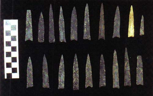
Plate 1: Norton-type Arrow Points. AM451:415
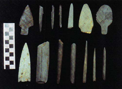
Plate 2: Slate Points, Knives, and "Pins." Top L to R AM451: 39, beach, 389, 96, 201. Bottom 219, 13, 312, 74, 19, 40.
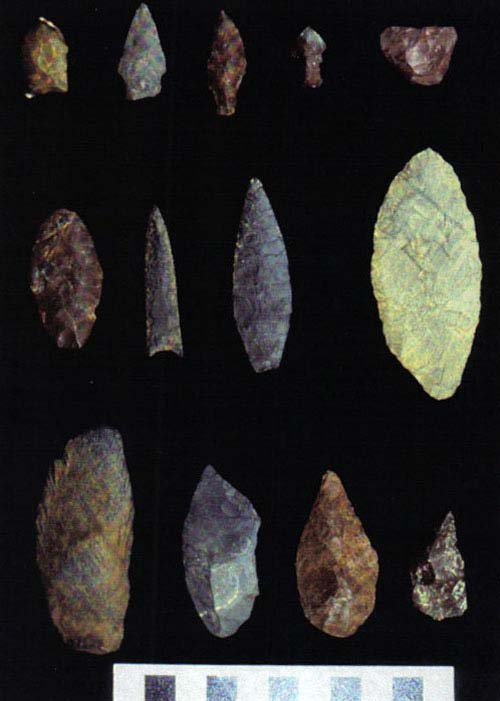
Plate 3: Flaked Artifacts. Top 230, 231, 44,70,409c; middle 309, 254, 267, 232; bottom 42, 395, 100,207.
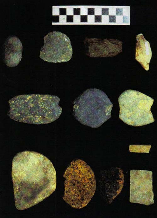
Plate 4: Various Objects. Right, grooved pebble AM451:322, smooth-edged cobble spall 334, adze 183, burnisher 196; middle column, notched pebbles 366, 385; left, whetstones 405, 37, pumice, 152, 47 (small bar).
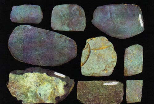
Plate 5: Ulu Blades, Chipped Ulu-shaped Scrapers, Saws. Saws 387, 293; Ulus 392, 257, 208, 83, 217; chipped blades 219, 123a.
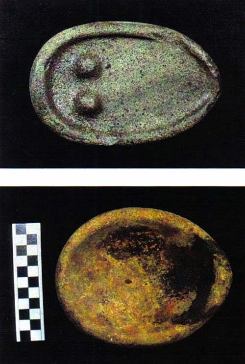
Plate 6: Lamps. Upper "breasted" lamp on the shore in 2000; lower AM451:52.
CATALOG: SITE AF0-010, AF0GNAK RIVER 2002 SEASON
All artifacts bear the Alutiiq Museum prefix "AM 451."
No. Identification Sect- Depth, Date Excava-
AM451 ion Layer 2002 tor
__________ _____________ _____________________________________________
1a, b Chert flakes 8 Brn below 6-20 DWC
top of black soil
2 Ground slate frag. A Above floor 6-25/27 DWC
3 Pebble A " " " "
4a-d Chert flakes A " "
5 Ulu frag. 4 Top black 6-25 DWC
6 Tool slate 4 " "
7 Cobble spall 4 " "
8 Cobble chopper 4 " "
9 Chert core 4 " "
10a-d Chert flakes 4 " "
11 Hone (stone) block 6 Inside hearth 6-25 DWC
12 Chert biface frag. 6 10 cm -Kat. 6-25 DWC
13 Slate lance frag. 5 8 cm -Kat with 6-25 DWC
hearth slabs
14a-b Chert flake 3 Level bag 6-28 CindySP
15 Ground slate frag. 5 Level bag 6-25 DWC
16 Ulu frag. 5 " " 6-25 DWC
17 Single notched pebble 5 " "
18a-d Chert 5 " "
19 Slate awl 4 7 cm -Kat., black 6-25 DWC
20 Around & over-end 4 15/20 cm -Kat in 6-25 DWC
grooved cobble gray sandy
21 Notched pebble B 10cm -Kat. 6-28 DWC
22 Notched pebble B 4cm -Kat. 6-27 Dawson
23 Notched pebble B " "
24 Ulu frag.. A/B 3 cm -Kat, black 6-28 DWC
25 Chipped ulu 3 12 cm -Kat 6-28 CindySP
26 Pumice " "
27 Incised pebble A With slate slabs 6-28 DWC
28 Ulu frag. 2 32 cm -Kat, black 6-28 Holmes
29a-c Pebbles B Down to and 6-28 DWC
30 Tool slate B within stone slab "
31 Ulu chip " zone. "
32 Chipped schist tablet " "
33 Pebble spall " "
34 Small pebble spall " "
35 Pointy pebble " "
36 7 chert & other flakes " "
37 Pumice abrader A 44 cm -Kat. Under 6-29 DWC
stone slab
No. Identification Sect- Depth, Date Excava-
AM451 ion Layer 2002 tor
__________ _____________ _____________________________________________
38 Incised tablet 15 9 cm -Kat 7-08 Dcap
39 Slate spear tip D 01 -Kat. 7-09 DWC
40 Slate "awl" C 23 -Kat, 25 + floor 7-08 DWC
41 Cobble spall C Just + brn floor 7-09 DWC
42 Used macroblade C 32 cm -Kat. 7-09 DWC
43 Notched stone, half D 9 cm -Kat. 7-08 DWC
44 Chert piece D up R 20 cm -Kat. 7-10 DWC
45 Hone C 39 cm -Kat. 7-09 DWC
46 Notched pebble B/C 2 cm -Kat. 7-09 DWC
47 Bar whetstone C 18 cm -Kat. 7-09 DWC
48 Slate "awl" 13 64 cm -Kat. 7-10 Meagan
49 Sandstone slab C Next to lamp near
level of floor 7-09 DWC
50 Stone chunk w 4 grooves " "
51 Pitted cobble " "
52 Lamp C To its top, 30 -Kat, 7-09 DWC
its wickend just above floor level at top
of cleft or linear hole in floor. Brn soil.
54 cm up R from section edge.
53 Iron mineral 13 --- 7-09 Meagan
54a-c Pebbles C&D Above floor 7-09/10 DWC
55 Rock #51 lithology " "
56 Ulu frag. " "
57 14 red,1 tan chert " "
58 Pigment pebble " "
59 Ulu frag. D 5 cm -Kat. bl. soil 7-10 DWC
60 Split shingle D 14 cm -Kat. 7-10 DWC
61 Slate point frag. D 8 cm -Kat. 7-10 DWC
62 Large ulu blade D 23 -Kat. right atop 7-10 DWC
large stone slab
63 Notched pebble 13 1 cm -Kat? (blur) ? ?
64 Flaked frag. Point tip. F 26 cm -Kat. R end 7-11 DWC
65 Adze frag. F 20 cm -Kat. 7-11 DWC
66 Well-rounded cobble C 26 cm -Kat to top 7-10 DWC
67 Red pumice A/D Above floor 7-08 DWC
68 Split cobble " "
69 12 chert (11 red) " "
70 Stubby chert point shore In front of trench July DWC
NC Little-used cobble hammer 4 20cm -Kat. 6-25 DWC
71 Slate pin 16/17 Among slate slabs 7-20 DWC
Down R 1/2
72 Slate pin 8 57 cm -Kat. 7-17 Flora Shan.
73 Slate pin frag. G 48 cm -Kat. 7-17 DWC
No. Identification Sect- Depth, Date Excava-
AM451 ion Layer 2002 tor
__________ _____________ _____________________________________________
74 Slate pin frag. 17 Less than 10 cm -Kat 7-19 Chad
Down R half
75 Red pumice abrader 8 30 cm -Kat. 7-17 Flora Shan-
(in bag, not marked) igan
76 Notched sinker 8 Deep 7-17 " "
77 Red pumice abrader F 42 cm -Kat. 7-16 DWC
(in bag, not marked)
78 Ulu frag. G On floor 7-18 DWC
79 " "
80 " "
81 " "
82 " F/G 33 -Kat. 7-16 DWC
83 Ulu, whole F 40 -Kat. 7-16 DWC
84 Ulu frag G 66 -Kat. brn sub floor 7-18 DWC.
85 Ulu frag. 16 - - Meagan
86 Slate knife frag, 2 holes G 34 cm -Kat. 7-17 DWC
87 Ulu frag. G Deep, brn subfloor 7-18 DWC
on edge
88 Ulu frag. G 70 -Kat in hole 7-18 DWC
89 Ulu frag. 16 Up At lev of brn floor 7-20 DWC
90 Ulu frag. but at loc where 7-20 DWC
higher matrix fills a depression
91 Notched pebble D 12 -Kat. above slabs 7-10 DWC
92 Notched pebble G 47 cm -Kat. 7-17 DWC
93 Notched pebble G 13 cm -Kat. 7-17 DWC
94 Notched pebble G 43 cm -Kat. 7-18 DWC
95 Maul frag. 8 63 cm -Kat. 7-17 Flora S.
96 Double-edged knife blade G 55 -Kat. near base of 7-18 DWC
brn subfloor at edge of
stone slab covering a pit
97 Red jewelry stone - in 16 Up 46 -Kat. in dark soily 7-20 DWC
bag not marked sand below lg rock
98 Rough chert biface G 36 cm -Kat 7-17 DWC
99 Rough chert biface frag. F 54 cm -Kat. 7-16 DWC
100 Chert biface 17 Above slabs, less 7-19 Chad
down than 10 cm -Kat.
101 Chert biface frag. G 12 cm -Kat. 7-16 DWC
102 Chert flake 5 Top of deposit 6-20 DWC
103 Red pigment stone G 42 cm -Kat. 6-17 S. Price
104 Yellow chert piece H - 7-19 Meagan
105 Red chert H - 7-19 Meagan
106 Adze chip H - 7-19 Meagan
107 Marginal ulu H - 7-19 Meagan
No. Identification Sect- Depth, Date Excava-
AM451 ion Layer 2002 tor
__________ _____________ _____________________________________________
108 Chert chunk -core H 40 cm -Kat. 7-19 John Ignatin
109 Sawn slate cut-off 1/16 Deep in dk gray sandy 7-20 DWC
47 cm -Kat.
110 Scraper or natural rock G Just above floor 7-17 DWC
111 Hone 16Up Under lg burned rock 7-20 DWC
112 Pigment stone Information is same as that for 89 & 90
113 Cobble spall 16 Top through FCR & 7-18/20 DWC
114 Cobble spall 16 slate slab level " "
115 Hammerstone frag " "
116 Elongate hammerstone " "
117 Hammerstone " "
118 Tool slate " "
119 Maul cobble " "
119a-m Slate scrap frags. G 7-16/17 DWC
120a-z Chert flakes " "
121a-c Pebbles " "
122a-b Cobble flake frag. " "
123a-b Schist tablet & frag. " "
124 Other stone frag. " "
125a-b Cobble spall G Lower depths 7-18 DWC
126a-c Slate scrap " "
127 Elongate beach pebble " "
128 Red pebble " "
129 Yellow chert flake " "
130a-h Chert flakes " "
131 Piece of quartz " "
132 Pointed slate splinter 17 Dn With stone slabs 7-19/20 DWC
133 Maul frag. " "
134 Hammerstone " "
135a-c Slate scrap " "
136a-g Chert flakes " "
137 Sandstone abrader 16 Up 30 -Kat. under lg. 7-20 DWC
rx next to fine hone
138 Fine abrader E 18 cm -Kat. 7-16 DWC
139a-d Cobble spalls 16 Deep to 47 -Kat. in 7-20 DWC
dk gray sandy soil
140a-c Slate scrap " "
141 Ulu frag. " "
142 Pebble rod frag. " "
143 Chert flakes, 1 bifaced " "
144 Yellow-green chert flake " "
145 Lg. flaked schist blade " "
146a-c Pebbles F 7-16 DWC
No. Identification Sect- Depth, Date Excava-
AM451 ion Layer 2002 tor
__________ _____________ _____________________________________________
147 Slate scrap " "
148a-q Chert flakes (k biface?) " "
149 Ulu frag. of schist " "
150 Hammerstone 17Dn 7-19 Chad
151 Hammerstone frag. " Chad
152 Flake " "
153 Chert flakes " "
154 Norton arrow tip G 40 + Kat. near hard 7-17 S. Price
base
NC 3 fist-size rounded cobbles 16/17 ca 15 -Kat. 7-27 DWC
No trace of use. Found together
155 Notched pebble 7 Under clay at 7-25 DWC
hearth, -45 Kat.
156 Notched pebble 2 64 cm -Kat. 7-25 SAM-Wol
157 Notched pebble 17Dn Above slabs, -7 Kat. 7-26 DWC
158 Notched pebble D Far below slate slabs 7-29 DWC
159 Notched pebble 1 68 -Kat. 7-27 Holmes
160 Notched pebble 2 61 -Kat 7-27 Bethany
161 Notched pebble 2 64 -Kat 7-25 SAM (Wol.)
162 Notched pebble 3? - 7-27 Bethany
163 Notched pebble 18 Atop lg. slab, 17 -Kat 7-27 DWC
164 Notched pebble 16D 26 cm -Kat. 7-26 DWC
165 Notched pebble 1 70 -Kat. 7-27 Holmes
166, 67, 68 Notched pebbles 1 52 -Kat 7-27 Holmes
169 Notched pebble frag. D Well below stones 7-29 Mary L.
170 Pebble with 1 side notch A Under stone slab 7-28 DWC
171 Split notched pebble? 18 35 -Kat 7-27 DWC
172` Unfinished notched pebble 17 12 -Kat. above slabs 7-27 DWC
173 Large notched pebble 18 Very top, 0 -Kat. 7-27 DWC
174 Flat pebble, sinker blank? 16-17D Misc. lot 7-26 DWC
175-76 " " 17 D Misc. lot 7-27 DWC
177-179 " " - Misc. lot 7-26 DWC
179b " " D Misc. lot 7-28 DWC
180 Hammerstone 13 32 -Kat. 7-29 DWC
181 Maul/grinder 16 D 12 -Kat. 7-26 DWC
182 Cobble, natural D Well -stone slabs 7-29 DWC
183 Adze bit 18 11 cm -Kat, + slabs 7-27 DWC
184 Whetstone frag. 17 +slabs, 17 cm -Kat. 7-27 DWC
185 Cobble spall B Near till at base of 7-29 DWC
localized soft fill
186-90 Cobble spalls 17 D Misc. lot 7-27 DWC
188 is retouched & annex
191-93 Cobble spalls - - - -
No. Identification Sect- Depth, Date Excava-
AM451 ion Layer 2002 tor
__________ _____________ _____________________________________________
194-195 Cobble spalls 16+17 Misc. lot 7-24 DWC
196 Burnisher B Under stone slabs 7-24 DWC
197 Bead 1 34 -Kat, -cobbles - Holmes
198 Whetstone frag B Under slab 7-28 DWC
199 Large hone block 16Up 28 -Kat. 7-24 DWC
199b Whetstone 16Dn Extension 36 -Kat - DWC
200 Pumice D Below stone slabs 7-29 Mary Lu
201 Stemmed slate blade 16Dn 14 -Kat. 7-26 DWC
202 Slate point section 17Dn Extension. 11 -Kat., 7-27 DWC
above stone slabs
203 Slate end-blade 17Dn 24 -Kat., + slabs 7-27 DWC
204 Slate "awl" frag. 17Dn 19 cm -Kat. 7-26 DWC
205 Slate "awl" frag. 16Up 25 cm -Kat; -slabs 7-24 DWC
206 " " poor 16&17 Up 18 cm -Kat. 7-24 DWC
207 Ulu frag. 16&17 Up 22 cm -Kat. 7-24 DWC
208 Ulu 2 42 cm -Kat. - Cla
209 Slate "awl" frag. 17Dn 13 cm -Kat. 7-27 DWC
210 Ulu half B Under stone slab 7-28 J.Ignatin
211 Ulu frag B " " 7-28 J.Ignatin
212 Ulu frag. D Under stone slabs 7-28 DWC
213 Ulu frag. D? Near floor 7-29 Mary Lu
214 Ulu blade 3 30 -Kat. 7-25 SAM Wol.
215 Ulu frag. B 32 -Kat. 7-29 DWC
216 Ulu frag. B Below slabs 7-28 DWC
217 Whole ulu blade B 51 -Kat at up R edge 7-28 DWC
of blue clay band
218 Ulu, large D 27 -Kat, -stone slab 7-29 DWC
219 Flaked ulu, large D Below stone slabs 7-29 Mary Lu
220a-c 3 ulu frags. B `Miscell. -stone slabs 7-29 DWC
221a-u Chert flakes B " " 7-29 DWC
222a-d Ulu frags. 16&17 Miscell. Lot 7-24 DWC
223 Ground slate frag. " "
224a-b Pebbles " "
225 1 quartz, 9 chert flakes " "
226 Saw frag? 16 Dn 11 -Kat. 7-26 DWC
227 Chert gjouge? B 62 -Kat;10 cm from 7-29 DWC
` clay band,20 cm deeper
228a-c Chert flakes 16&17 Miscell. Lot 7-29 DWC
229 Chert biface frag. B 42 cm -Kat. 7-29 Mary Lu
230 Point, yellow chert 3 45 -Kat 7-25 SAM Wol
231 Stemmed poin t D well -stone slabs 7-29 Mary Lu
232 Leaf-shaped biface D " " " "
233 Flaked tip frag. 3 57 -Kat. 7-28 Pruitt
No. Identification Sect- Depth, Date Excava-
AM451 ion Layer 2002 tor
__________ _____________ _____________________________________________
234 Lg. flaked stemmed biface A/B Under slabs - DWC
235 Sm. Shaped pc. red sst. 16Up 37 -Kat. 7-24 DWC
(not marked, in bag)
236a-b Worked tool slate - - - -
237 Sm. Slate bar slightly 17 Miscell. Lot 7-27 DWC
touched by grinding.
238 ulu, small frag. " "
239 Tool slate " "
240 Whetstone frag " "
241 7 red chert flakes " "
242 Notched pebble 1 70 cm -Kat, 8-06 DWC
243 Ulu frag. 3 44 -Kat. under slab 8-06 DWC
244 " " 2 61 -Kat. near floor 8-08 DWC
245a-b 2 notched pebbles 1 73 -Kat. floor 8-06 DWC
246 Notched pebble 2 75 cm - Kat. top of - DWC
butter clay
247 Notched pebble 3/4 34 cm -Kat. 8-06 DWC
248a-d Ground slate frags, at least 2 from ulus 17 Misc. lot 7-27 DWC
249 Worn cobble spall frag. " "
250 Stone saw? (blunt edge) " "
251a-b Tool slate " "
253 Ulu frag. 1 73 cm -Kat. 8-06 DWC
254 Cobble spall 3 30 -Kat, lg. rx lev bg 8-06 DWC
255 6 Notched pebbles 1 78 -Kat. floor, in 10- 8-06 DWC
in-long group
256 Ulu frag. 16Up 64 -Kat. 8-06 DWC
257 Large ulu 3 47 Kat. up R wall 8-06 DWC
258 Notched pebble 1 50 -Kat. brn basal 8-05 DWC
259 31 notched pebbles G 64 -Kat. in compact 8-04 DWC
brn floor, clustered
260 Ulu G 64 -Kat. brn floor 8-04 DWC
261 Flaked slate ulu blade E 38 cm -Kat. 8-03 DWC
262 Notched pebble frag. 1 21/46 -Kat. 8-03 DWC
263 Ulu frag. D Bl-dk brn above 8-06 DWC
basal brown
264 Chert biface C 60 -Kat. 8-03 DWC
265 Pencil point B 50 -Kat 8-04 DWC
266 Slate "awl" 7 8-05 JRI
267` Flaked point D Under slab, -11 Kat 8-06 JRI
268 Ulu blank D Mixed basal brn at 8-06 DWC
at top of narrow hole lined by 2 vert. rocks in a place where pre-Kat. surf. dips atypically; next to clay-lined pit..
No. Identification Sect- Depth, Date Excava-
AM451 ion Layer 2002 tor
__________ _____________ _____________________________________________
269 Ulu, damaged D " "
270 Ulu, unfin? 3 52 -Kat. below lg. rx. 8-05 DWC
271 Tip-shaped tool frag. B 47 -Kat 8-04 DWC
272 Ulu frag. B 53 -Kat., lt. Brn. soil 8-04 DWC
273 Slate spear head C 60 -Kat. 8-03 DWC
274 Ulu frag. D 63 -Kat on floor 8-03 DWC
275 Red pumice abrader D 47 -Kat. 8-04 JRI
(c 1 1/2 in sq. not marked)
276 Ulu frag. B 48 -Kat 8-04 DWC
277 Ulu frag. E 57 -Kat. edge up 8-04 DWC
278 Miscellaneous lot 1 Lower levels 8-05 DWC
b Granitic pebble
c Scraper or saw rablet
d Small split hammerstone
e 4 chert flakes
f Split cobble
279 Sinker with extremely 1 Lower levels " "
tiny cut notches
280 Miscellaneous lot B, C Below stone slab 8-05 & DWC
a 3 cobble spalls D slab layer " "
b 5 small pebbles
c 3 large pebbles
d Split cobble hammerstone
e 27 chert flakes
f 10 worked or tool slate
g Sinker?
281 Small hone " "
282 Ulu frag. 16Up -59 Kat. 8-08 DWC
283 " "
284 Sawn slate 16Up 39 -Kat 8-05 DWC
285 Notched pebble 16Up 74 -Kat. 8-08 DWC
286 Ulu 7 edge of blue clay basin 8-08 DWC
287a-d Notched pebble 16Up 62, 71 & 72 -Kat. 8-08 DWC
288 Ulu frag. 16Up 60 -Kat. 8-08 DWC
289 " "
290 " "
291 " "
292 Slate spear tip frag. 13 Deep, 37 -Kat. 8-08 DWC
293 Saw
294 Hone block 16Up 57 cm -Kat. 8-08 DWC
295 Ulu frag. 5 &4/5 37 -Kat. 8-07 DWC
296 " "
297 " "
No. Identification Sect- Depth, Date Excava-
AM451 ion Layer 2002 tor
__________ _____________ _____________________________________________
298 " "
299 " "
300 " "
301 " "
302 " "
303 Stone saw 5 37 -Kat. 8-07 DWC
295-303 in dk gray deposit below an orange band
304 Miscellaineous 3 Lower DWC
some 4
a Quartz hammerstone
b 3 Cobble spalls
c Small stone sphere
d 2 Pebbles
c Thin shingle
d 3 Chert flakes
e Slate with saw scratch
f Tabular scraper or saw
g 2 slate
305 Miscellaneous lot 16Up Below slabs 8-08 DWC
a 2 Cobble spall
b 14 various slate
c Saw or coarse ulu frag
d Small sphere
e 2 Pebbles
f 4 Chert flakes
g Rough chert biface frag.
h Split beach shingle
307 Slate pin, frag., unfin. 4/5 26 cm -Kat. 8-07 DWC
308 Yellow-green chert 4 21 cm -Kat. 8-07 DWC
amid angular blocks
309 Chert biface I 8 cm -Kat. 8-07 DWC
310 Slate point frag 16Up 38 cm -Kat. 8-07 DWC
311 Slate pin 5 33 cm -Kat. 8-06 JRI
312 Slate pin I 12 cm -Kat 8-07 JRI
313 Pumice 16Up 38 cm -Kat 8-07 DWC
314 Flaked slate blank? 14 48 cm -Kat. 8-08 DWC
315 Notched pebble 1 60 cm -Kat 8-06 DWC
316 Point frag. H 96 -Kat. 8-06 JRI
317 Chipped slate blade 16Up 43 -Kat. 8-07 DWC
318 Sinker 1 65 cm -Kat. 8-06 DWC
319 Notched pebble 1/16 76 -Kat 8-06 DWC
320 Notched pebble 5 16 cm -Kat. 8-07 DWC
321 Notched pebble 5 44 -Kat. on till 8-07 DWC
No. Identification Sect- Depth, Date Excava-
AM451 ion Layer 2002 tor
__________ _____________ _____________________________________________
322 Grooved pebble 4 Dk gray soil 8-07 DWC
323 Notched pebble 14 48 -Kat. 8-08 DWC
324 Sawn slate 16Up 40 cm -Kat. 8-07 DWC
325 Partial grooved cobble B 62 cm -Kat. 8-04 DWC
326 Large cobble spall 6 Outer edge of clay- 8-08 DWC
lined basin near base
327 Hammerstone, natural groove 7/8 Base of clay-lined pit 8-09 DWC
328a-b Elongate cobble hammer- B Together atop slate 7-29 DWC
stone & long cobble rod slab at base site 67-K
329 Maul 5 Depression in floor, 8-07 DWC
30 cm from #330
330 Large maul 5 " 329 "
331 Small maul frag. " "
332 Cobble 1/2 Deep. Holmes left 7-29
in the trench
333 Cobble spall, smooth edge 6/7 Deep 8-09 DWC
334 Cobble spall 13 48 -Kat. 8-09 DWC
335 Notched pebble 7 29 -Kat. near floor 8-09 DWC
336 Ulu frag. 16U 76 cm -Kat. 8-08 DWC
337 Notched pebble 16U 83 -Kat. in pit 8-09 DWC
338 Ulu frag. 7 24 cm -Kat 8-09 DWC
339 Cobble spall, smooth edge 6 35 -Kat. varied clay 8-09 DWC
340 Unusual chert flake 16/17D 9 cm -Kat. 7-26 DWC
341 Miscellaneous 4/5, 13 Deep to floor 8-09 DWC
a Hammerstone
b Cob ble spall
c Stone saw?
d 2 Chert flake
e Pebble
f 2 ulu frag.
g 4 other worked slate & tool slate
342 Slate blade with unprep edge 16U Just below slabs 8-11 Monigold
343 Ulu frag. 17D 37 cm -Kat, 8-11 David K.
344 Ulu 17D Below slabs 8-11 DWC
345 Ulu frag. 16Up 35 cm -Kat 8-11 RJMonigold
346 Ulu 17Up 12 cm -Kat. 8-11 MMH
347 Scraper " "
348 Ulu double edged 17D 35 cm -Kat. 8-11 DWC
349 Slate pin 17U 34 cm -Kat 8-11 LNB
350 half a notched pebble 17D 43 cm -Kat. 8-11 DK
351 Notched pebble 17Up 12 cm -Kat 8-11 MMH
352 Notched pebble 17D 42 -Kat. 8-11 David K
353 Notched pebble 16Up Under slabs 8-11 Monigold
No. Identification Sect- Depth, Date Excava-
AM451 ion Layer 2002 tor
__________ _____________ _____________________________________________
354 Notched pebble 17D 36 cm -Kat. 8-11 David C
355 Notched pebble 17Up 60 -Kat 8-11 DWC
356 Half of notched cobble 16D 35 cm -Kat 8-11 DWC
357 Notched pebble 17U 10 above floor 8-13 DWC
358 " " " 90 -Kat. 8-12 DWC
359-362 " " " 70, 71, 75, 82 -Kat. 8-13 DWC
363 " " 17D 69 cm -Kat. 8-13 BeCar
364 " " 16D 42 cm -Kat. 8-12 DC
365 " " 17D 36 cm -Kat. 8-12 DC
366 " " 16U 33 cm -Kat. 8-12 DVC
367 " " !6U 66 cm -Kat. 8-12 DWC
368 " " 17D 41 cm -Kat. 8-12 DC
370 " " 16U 77 cm -Kat. 8-12 DWC
369 " " 17U 84 cm -Kat. 8-13 DWC
371 " " 16U 77 cm -Kat. 8-12 DWC
372 White pumice abrader 17D 42 cm -Kat. 8-12 Dcap
not marked, in bag, part broken off
373 " " 17U 56 cm -Kat. 8-12 DWC
374 " " 17U 68 cm -Kat. 8-12 DWC
375 " " 17U 48 cm -Kat. 8-12 DWC
376 " " 18 30 cm -Kat. 8-12 Dcap
377-78-79 " " 16U/D 66 cm -Kat. 8-13 DWC
380-81 " " 17U 65 cm -Kat. 8-13 DWC
382-383 " " 17U 72 -Kat. 8-12 DWC
385 18 net sinkers 16D 65 cm -Kat. 8-13 DCap
386 Slate point frag. 17U 68 cm -Kat. 8-12 DWC
387 Stone saw 17U 38 cm -Kat. 8-12 DWC
388 Ulu fragment 18 40 cm -Kat. 8-12 DWC
389 Slate tip fragment 17U 48 cm -Kat. 8-12 DWC
390 Ulu blade 17U 58 cm -Kat. 8-13 DWC
391 Ulo blade 17U 41 cm -Kat. 8-12 DWC
392 Ulu blade Backdirt 8-12 JI
393 End-grooved cobble 17U 79 cm -Kat. 8-13 DWC
394 Ulu frag. 17U 32 cm -Kat. 8-12 DWC
395 Basalt knife on a flake 16U 65 cm -Kat. 8-12 DWC
396 Pumice abrader 17D 45 cm -Kat. 8-13 Dcap
not marked, in bag
397 Pointed slate knife frag. 17U 38 cm -Kat. 8-12 DWC
398 Ulu frag. 17D 24 cm -Kat. 8-12 DWC
399 Sst abrader frag. 16U 48 cm -Kat. 8--- DWC
400 Ulu frag. 17U 75 -Kat. on edge fill 8-12 DWC
401 Blunt edged ulu 17U 38 cm -Kat. 8-12 DWC
403 Miscellaneous lot 17U --------- DWC
No. Identification Sect- Depth, Date Excava-
AM451 ion Layer 2002 tor
__________ _____________ _____________________________________________
a 10 chert flakes
b 3 cobble spalls
c spall, edge ground sharp
d 2 slate scrap
e Beach shingle hammerstone
f 2 small battered shingles
g Pebble
h Cobble
404 Miscellaneous I ---------- JI
a ca 25 chert flakes, all but 1 red
b Ulu frag.
c Biface frag.
405 Hone 17U From misc. lot DWC
406 Miscell. 17U ---------- 8-11
a 5 chert flakes
b Ulu frag.
c 2 cobble spalls
d split shingle, used edge?
e section of beach rod
407 Hone 17U 48 cm -Kat. 8-13 DWC
408 Miscellaneous 16U ----- 8-11 Moni
a 2 chert flakes
b Chert biface frag.
c cobble spall
d Beach rod hammerstone
409 Bead frag. 17D 30 -Kat. 8-12 Dcap
410 Miscellaneous 17U 8-13 DWC
a Coble spall
b Pebble sphere
c Cobble
d Cobble hammerstone
e Maul fragment
411 Abrader 17U 50 cm -Kat. 8-12 DWC
412 Miscellaineous 16D --------- 8-13 ---
a 4 slate scrap
b 7 ulo frag.
c 2 chert flakes
413 Miscellaneous 17U --- 8-12 DWC
7 chert
1 tabular hone
1 bar-shaped hone frag.
3 ulu frags.
1 pc. Slate
No. Identification Sect- Depth, Date Excava-
AM451 ion Layer 2002 tor
__________ _____________ _____________________________________________
414 Miscellaneous 17D ---- 8-13 Dcap
hammerstone
5 chert flakes
pebble
10 slate scraps
fragment of calcined bone
415 18 Norton-style lanceolate 17U on very floor of entry 8-12 & DWC
arrow points some on glacial till 8-13
The points were clustered. One and fragments were recovered on the screen.


© Copyright 2018 Native Village of Afognak ~ all rights reserved